IMAGES TAKEN NEAR TO
Riverlight Quay, LONDON, SW11 8DX
Introduction
This page details the photographs taken nearby to Riverlight Quay, SW11 8DX by members of the Geograph project.
The Geograph project started in 2005 with the aim of publishing, organising and preserving representative images for every square kilometre of Great Britain, Ireland and the Isle of Man.

There are currently over 7.5m images from over14,400 individuals and you can help contribute to the project by visiting https://www.geograph.org.uk
Image Map
Images are licensed for reuse under creativecommons.org/licenses/by-sa/2.0
Notes
- Clicking on the map will re-center to the selected point.
- The higher the marker number, the further away the image location is from the centre of the postcode.
Image Listing (303 Images Found)
Images are licensed for reuse under creativecommons.org/licenses/by-sa/2.0
Image
Details
Distance
1
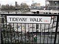
Tideway footpath
Between Nine Elms Pier and the Riverlight housing development.
Image: © Thomas Nugent
Taken: 19 May 2014
0.02 miles
2
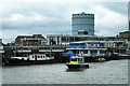
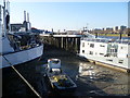
Pier, Nine Elms
Most of the boats are houseboats.
Image: © Robin Webster
Taken: 11 Aug 2011
0.02 miles
3
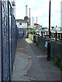
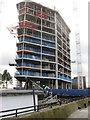
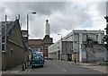
Kirtling Street (2)
The building ahead is currently a Securicor depot, something I only discovered online as I did not see any signs or even an entrance. Two of Battersea Power Station's chimneys can be seen on the right.
Sandwiched between Nine Elms Lane, the power station and the Thames, Kirtling Street and environs are a bit of a curiosity, a small relic of a bygone age with their resolutely unglamorous industrial buildings and patches of wasteland. The area's resistance to the tide of gentrification may not, however, last for much longer if a £5.5 billion redevelopment plan centred around the power station proceeds. The first hurdle has been jumped - Wandsworth Council granted planning consent in November 2010.
Image: © Stephen Richards
Taken: Unknown
0.02 miles
4
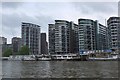
Riverlight Quay flats
Apartment blocks by the Thames at Nine Elms.
Image: © Jim Barton
Taken: 21 May 2016
0.03 miles
5
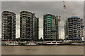
Riverlight Quay
Riverside development at Nine Elms, seen across the Thames from Pimlico
Image: © Richard Croft
Taken: 3 Aug 2015
0.03 miles
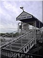
8
Nine Elms Pier
Because of construction work, the Thames Path just beyond Nine Elms Pier had been blocked off so it was necessary to return the same way. On the left in the foreground is one of the houseboats of Tideway Village - see http://www.geograph.org.uk/photo/2787366 whilst in the distance on the left are two of the chimneys of the disused Battersea Power Station.
Image: © Marathon
Taken: 1 Feb 2012
0.03 miles
9
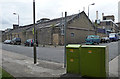
Kirtling Street (1)
On the left is a Securicor depot, on the right a warehouse, and beyond, two of Battersea Power Station's chimneys.
Sandwiched between Nine Elms Lane, the power station and the Thames, Kirtling Street and environs are a bit of a curiosity, a small relic of a bygone age with their resolutely unglamorous industrial buildings and patches of wasteland. The area's resistance to the tide of gentrification may not, however, last for much longer if a £5.5 billion redevelopment plan centred around the power station proceeds. The first hurdle has been jumped - Wandsworth Council granted planning consent in November 2010.
Image: © Stephen Richards
Taken: Unknown
0.03 miles