IMAGES TAKEN NEAR TO
Gayville Road, LONDON, SW11 6JP
Introduction
This page details the photographs taken nearby to Gayville Road, SW11 6JP by members of the Geograph project.
The Geograph project started in 2005 with the aim of publishing, organising and preserving representative images for every square kilometre of Great Britain, Ireland and the Isle of Man.

There are currently over 7.5m images from over14,400 individuals and you can help contribute to the project by visiting https://www.geograph.org.uk
Image Map
Images are licensed for reuse under creativecommons.org/licenses/by-sa/2.0
Notes
- Clicking on the map will re-center to the selected point.
- The higher the marker number, the further away the image location is from the centre of the postcode.
Image Listing (90 Images Found)
Images are licensed for reuse under creativecommons.org/licenses/by-sa/2.0
Image
Details
Distance
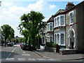
2
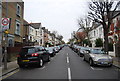
Broomwood Road, near Clapham Junction
Broomwood Road, at its junction with Northcote Road.
Image: © Malc McDonald
Taken: 9 Jul 2016
0.11 miles
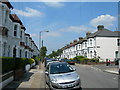
3
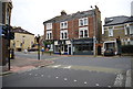
Honeywell Road SW11
Looking towards Northcote Road.
Image: © Danny P Robinson
Taken: 16 Jun 2006
0.11 miles
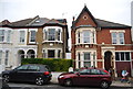
4
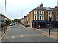
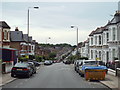
Wroughton Road SW11
At the corner of Roseneath Road, looking towards Broomwood Road. A lot of the roads near here are very similar to this in appearance.
Image: © Danny P Robinson
Taken: 16 Jun 2006
0.11 miles
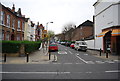
8
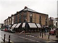
The Bollingbroke, Wandsworth
Public house on the junction of Northcote Road (on the left) and Honeywell Road (on the right).
Image: © David Anstiss
Taken: 3 Jun 2012
0.14 miles