IMAGES TAKEN NEAR TO
Roseneath Road, LONDON, SW11 6AG
Introduction
This page details the photographs taken nearby to Roseneath Road, SW11 6AG by members of the Geograph project.
The Geograph project started in 2005 with the aim of publishing, organising and preserving representative images for every square kilometre of Great Britain, Ireland and the Isle of Man.

There are currently over 7.5m images from over14,400 individuals and you can help contribute to the project by visiting https://www.geograph.org.uk
Image Map
Images are licensed for reuse under creativecommons.org/licenses/by-sa/2.0
Notes
- Clicking on the map will re-center to the selected point.
- The higher the marker number, the further away the image location is from the centre of the postcode.
Image Listing (78 Images Found)
Images are licensed for reuse under creativecommons.org/licenses/by-sa/2.0
Image
Details
Distance
2
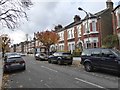
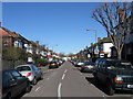
Thurleigh Avenue, Clapham
Avenue viewed from Nightingale Lane
Image: © Alex McGregor
Taken: 8 Mar 2010
0.10 miles
3
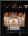
St Luke, Ramsden Road, London SW12 - Lady Chapel
Image: © John Salmon
Taken: 27 Apr 2003
0.11 miles
5
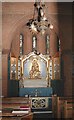
St Luke, Ramsden Road, London SW12 - Lady Chapel
Image: © John Salmon
Taken: 27 Apr 2003
0.11 miles
6

St Luke, Ramsden Road, London SW12 - Font
Image: © John Salmon
Taken: 27 Apr 2003
0.11 miles
7
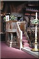
St Luke, Ramsden Road, London SW12 - Pulpit
Image: © John Salmon
Taken: 27 Apr 2003
0.11 miles
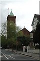
8
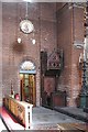
St Luke, Ramsden Road, London SW12 - Interior
Image: © John Salmon
Taken: 27 Apr 2003
0.11 miles
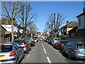
9
Holmside Road, Clapham
Road viewed from Nightingale Lane.
Image: © Alex McGregor
Taken: 8 Mar 2010
0.11 miles
