IMAGES TAKEN NEAR TO
Tyneham Close, LONDON, SW11 5XN
Introduction
This page details the photographs taken nearby to Tyneham Close, SW11 5XN by members of the Geograph project.
The Geograph project started in 2005 with the aim of publishing, organising and preserving representative images for every square kilometre of Great Britain, Ireland and the Isle of Man.

There are currently over 7.5m images from over14,400 individuals and you can help contribute to the project by visiting https://www.geograph.org.uk
Image Map
Images are licensed for reuse under creativecommons.org/licenses/by-sa/2.0
Notes
- Clicking on the map will re-center to the selected point.
- The higher the marker number, the further away the image location is from the centre of the postcode.
Image Listing (99 Images Found)
Images are licensed for reuse under creativecommons.org/licenses/by-sa/2.0
Image
Details
Distance
1
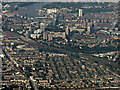
Clapham and Battersea from the air
Clapham Junction railway station is on the left, the River Thames and Fulham in the background.
Image: © Thomas Nugent
Taken: 26 Aug 2019
0.03 miles
2
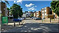
Ashley Crescent Estate
Modern blocks of flats in Clapham.
Image: © James Emmans
Taken: 28 May 2022
0.06 miles
4
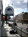
Welcome to Battersea sign, Lavender Hill SW11
Looking towards the junction with Audley Close
Image: © Robin Sones
Taken: 8 Aug 2011
0.10 miles
5
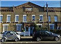
Victorian housing on Tyneham Road
This area is known as The Shaftesbury Estate - as indicated proudly under the eaves.
Image: © Neil Theasby
Taken: 25 Dec 2019
0.10 miles
6
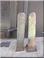
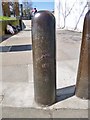
Old Boundary Marker by Wix's Lane, off Lavender Hill
Parish Boundary Marker by the footpath, in parish of Battersea (Wandsworth District), East side of Wix's Lane SW4, pedestrian section, just South of junction with Lavender Hill, in pavement to the left of Clapham post: SY_CLAP04pb Image
Inscription reads:-
BATTERSEA
1863
Surveyed
Milestone Society National ID: SY_BATT20pb
Image: © Milestone Society
Taken: Unknown
0.11 miles
7
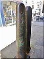
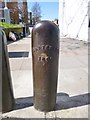
Old Boundary Marker by Wix's Lane, off Lavender Hill
Parish Boundary Marker by the footpath, in parish of Clapham (Lambeth District), East side of Wix's Lane SW4, pedestrian section, just South of junction with Lavender Hill in pavement next to Battersea post: SY_BATT20pb Image
Inscription reads:-
CLAPHAM
18(??)
(Plus inscription lower down)
Surveyed
Milestone Society National ID: SY_CLAP04pb
Image: © Milestone Society
Taken: Unknown
0.11 miles
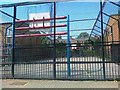
8
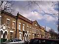
Shaftesbury Estate, Tyneham Road, Battersea
A maze of streets with identical 2 bedrooms houses. The houses were built in 1873 by Peabody for the poor working class. Many are now expensive private homes and the corner shops are empty.
Image: © Alex Walton-Keeffe
Taken: 14 Apr 2006
0.11 miles
9
Old Boundary Marker by the A3216, Queenstown Road, Clapham
Parish Boundary Marker by the A3216, in parish of Clapham (Lambeth District), Queenstown Road SW8, at cut-through to Ashley Crescent in pavement. 'CLAPHAM' post next to 'BATTERSEA 1866' post: SY_BATT21pb Image
Surveyed
Milestone Society National ID: SY_CLAP05pb
Image: © Milestone Society
Taken: Unknown
0.12 miles
10
Old Boundary Marker by the A3216, Queenstown Road, Battersea
Parish Boundary Marker by the A3216, in parish of Battersea (Wandsworth District), Queenstown Road SW8, at cut-through to Ashley Crescent in pavement next to Clapham post: SY_CLAP05pb Image
Inscription reads:-
BATTERSEA
1866
Surveyed
Milestone Society National ID: SY_BATT21pb
Image: © Milestone Society
Taken: Unknown
0.12 miles