IMAGES TAKEN NEAR TO
Craven Mews, LONDON, SW11 5PW
Introduction
This page details the photographs taken nearby to Craven Mews, SW11 5PW by members of the Geograph project.
The Geograph project started in 2005 with the aim of publishing, organising and preserving representative images for every square kilometre of Great Britain, Ireland and the Isle of Man.

There are currently over 7.5m images from over14,400 individuals and you can help contribute to the project by visiting https://www.geograph.org.uk
Image Map
Images are licensed for reuse under creativecommons.org/licenses/by-sa/2.0
Notes
- Clicking on the map will re-center to the selected point.
- The higher the marker number, the further away the image location is from the centre of the postcode.
Image Listing (89 Images Found)
Images are licensed for reuse under creativecommons.org/licenses/by-sa/2.0
Image
Details
Distance
1
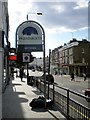
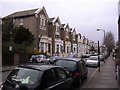
Welcome to Battersea sign, Lavender Hill SW11
Looking towards the junction with Audley Close
Image: © Robin Sones
Taken: 8 Aug 2011
0.03 miles
2
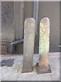
Old Boundary Marker by Wix's Lane, off Lavender Hill
Parish Boundary Marker by the footpath, in parish of Clapham (Lambeth District), East side of Wix's Lane SW4, pedestrian section, just South of junction with Lavender Hill in pavement next to Battersea post: SY_BATT20pb Image
Inscription reads:-
CLAPHAM
18(??)
(Plus inscription lower down)
Surveyed
Milestone Society National ID: SY_CLAP04pb
Image: © Milestone Society
Taken: Unknown
0.04 miles
3
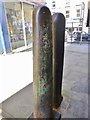
Old Boundary Marker by Wix's Lane, off Lavender Hill
Parish Boundary Marker by the footpath, in parish of Battersea (Wandsworth District), East side of Wix's Lane SW4, pedestrian section, just South of junction with Lavender Hill, in pavement to the left of Clapham post: SY_CLAP04pb Image
Inscription reads:-
BATTERSEA
1863
Surveyed
Milestone Society National ID: SY_BATT20pb
Image: © Milestone Society
Taken: Unknown
0.04 miles
4
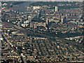
Clapham and Battersea from the air
Clapham Junction railway station is on the left, the River Thames and Fulham in the background.
Image: © Thomas Nugent
Taken: 26 Aug 2019
0.05 miles
5
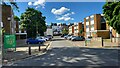
Ashley Crescent Estate
Modern blocks of flats in Clapham.
Image: © James Emmans
Taken: 28 May 2022
0.07 miles
6
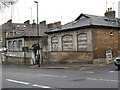
Cedars Motor Engineering Co
This building on Cedars Road displays a fascinating palimpsest of painted signs. It appears to have originally been a livery stable or similar, with signs including "horses bought or sold", "horses and carriages jobbed for any period", "traveller contracts" and "Broughams supplied".
In a later motorised age, these were over-written with signs such as "cars for hire", "weddings - theatres - stations", "repairs" and the name "Cedars Motor Eng'ing Com".
As of 2010 there was a property agent's sign promoting the site as a "development opportunity" so it could soon be gone.
Image: © Stephen Craven
Taken: 4 Feb 2010
0.07 miles
7
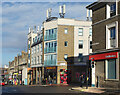
Sainsbury's on the Corner
The junction of Wandsworth and Queenstown Roads. Sainsbury's has the corner shop.
Image: © Des Blenkinsopp
Taken: 16 Nov 2022
0.08 miles
8
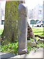
Old Boundary Marker by Wix's Lane, Battersea
Parish Boundary Marker by the footpath, in parish of Battersea (Wandsworth District), Wix's Lane SW4, pedestrian section, in pavement against tree.
Inscription reads:-
BATTERSEA
Surveyed
Milestone Society National ID: SY_BATT19pb
Image: © Milestone Society
Taken: Unknown
0.08 miles
9
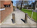
Clapham, bollards
North of this point, Wix's Lane becomes a footpath.
Image: © Mike Faherty
Taken: 20 Apr 2013
0.08 miles