IMAGES TAKEN NEAR TO
Nansen Road, LONDON, SW11 5NS
Introduction
This page details the photographs taken nearby to Nansen Road, SW11 5NS by members of the Geograph project.
The Geograph project started in 2005 with the aim of publishing, organising and preserving representative images for every square kilometre of Great Britain, Ireland and the Isle of Man.

There are currently over 7.5m images from over14,400 individuals and you can help contribute to the project by visiting https://www.geograph.org.uk
Image Map
Images are licensed for reuse under creativecommons.org/licenses/by-sa/2.0
Notes
- Clicking on the map will re-center to the selected point.
- The higher the marker number, the further away the image location is from the centre of the postcode.
Image Listing (81 Images Found)
Images are licensed for reuse under creativecommons.org/licenses/by-sa/2.0
Image
Details
Distance
2
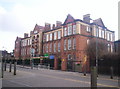
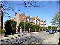
Wix Primary School (1903) & Lycee Charles de Gaulle
2 schools on one site in Wix's Lane, near Clapham Common. Soon to be the site of the first bilingual primary in the UK.
Image: © Alex Walton-Keeffe
Taken: 14 Apr 2006
0.10 miles
3
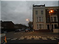
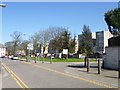
Stormont Road at the junction of Marney Road
Image: © David Howard
Taken: 24 Nov 2013
0.10 miles
5
Clapham, Wix Primary School
On Wix's Lane; sharing the site with Lycée Français Charles de Gaulle: http://www.wix.wandsworth.sch.uk/e/e_intro.asp http://www.ecolewix.org.uk/
Image: © Mike Faherty
Taken: 20 Apr 2013
0.12 miles
6
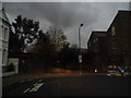
Clapham, open space
On Wix's Lane. The boundary between Wandsworth and Lambeth runs along the right hand side of the road.
Image: © Mike Faherty
Taken: 20 Apr 2013
0.13 miles
7

Old Boundary Marker by Wix's Lane, Battersea parish
Parish Boundary Marker by the UC road, in parish of Battersea (Wandsworth District), Wix's Lane SW4, opposite school, against wall at corner.
Inscription reads:-
BATTERSEA
Surveyed
Milestone Society National ID: SY_BATT18pb
Image: © Milestone Society
Taken: Unknown
0.13 miles
8
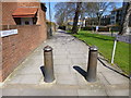
Clapham, bollards
North of this point, Wix's Lane becomes a footpath.
Image: © Mike Faherty
Taken: 20 Apr 2013
0.14 miles

10
Lavender Hill
At the corner of Stormont Road
Image: © David Howard
Taken: 24 Nov 2013
0.14 miles