IMAGES TAKEN NEAR TO
Culvert Road, LONDON, SW11 5AR
Introduction
This page details the photographs taken nearby to Culvert Road, SW11 5AR by members of the Geograph project.
The Geograph project started in 2005 with the aim of publishing, organising and preserving representative images for every square kilometre of Great Britain, Ireland and the Isle of Man.

There are currently over 7.5m images from over14,400 individuals and you can help contribute to the project by visiting https://www.geograph.org.uk
Image Map
Images are licensed for reuse under creativecommons.org/licenses/by-sa/2.0
Notes
- Clicking on the map will re-center to the selected point.
- The higher the marker number, the further away the image location is from the centre of the postcode.
Image Listing (57 Images Found)
Images are licensed for reuse under creativecommons.org/licenses/by-sa/2.0
Image
Details
Distance
1
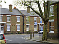
Chelsea support on Reform Street, SW11
Chelsea had beaten Liverpool 2-1 in the FA Cup Final the previous day.
Image: © Robin Webster
Taken: 6 May 2012
0.05 miles
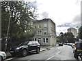
2
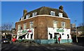
"The British Flag" public house on Culvert Road
Image: © Neil Theasby
Taken: 25 Dec 2019
0.06 miles
4
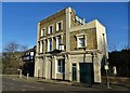
Former pub on Culvert Road
This was once the popular "Haberdashers Arms". It closed for business several years ago and is now a purely residential property. See https://www.closedpubs.co.uk/london/sw11_battersea_haberdashers.html
Image: © Neil Theasby
Taken: 25 Dec 2019
0.07 miles
5
Battersea, converted pub
Formerly Haberdashers Arms, on the corner of Dagnall Street and Culvert Road; once an extended staff room for Image Now private housing.
Image: © Mike Faherty
Taken: 20 Aug 2016
0.07 miles
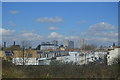
7
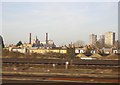
Battersea from the train
Looking west-north-west on the approach to Clapham Junction. The chimneys are those of Lots Road Power Station, across the river.
Image: © Christopher Hilton
Taken: 13 Jan 2012
0.08 miles
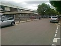
8
Battersea, academy
The original entrance, on Dagnall Street. The school was an early ILEA comprehensive, founded as Battersea County School; later Battersea Technology College, and its latest incarnation, Harris Academy Battersea. http://www.harrisbattersea.org.uk/
Image: © Mike Faherty
Taken: 20 Aug 2016
0.09 miles
9
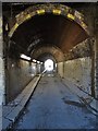
Tunnel below the railway - Culvert Road
Image: © Neil Theasby
Taken: 25 Dec 2019
0.10 miles
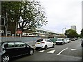
10
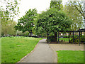
Latchmere recreation ground
The more park-like end of this small area bounded by Burns Road and Reform Street.
Image: © Robin Webster
Taken: 6 May 2012
0.10 miles