IMAGES TAKEN NEAR TO
Watford Close, LONDON, SW11 4QS
Introduction
This page details the photographs taken nearby to Watford Close, SW11 4QS by members of the Geograph project.
The Geograph project started in 2005 with the aim of publishing, organising and preserving representative images for every square kilometre of Great Britain, Ireland and the Isle of Man.

There are currently over 7.5m images from over14,400 individuals and you can help contribute to the project by visiting https://www.geograph.org.uk
Image Map
Images are licensed for reuse under creativecommons.org/licenses/by-sa/2.0
Notes
- Clicking on the map will re-center to the selected point.
- The higher the marker number, the further away the image location is from the centre of the postcode.
Image Listing (61 Images Found)
Images are licensed for reuse under creativecommons.org/licenses/by-sa/2.0
Image
Details
Distance
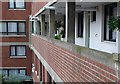
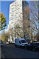
2
Hervey Court, Battersea, London
A late 20th century social housing development now mainly in private hands.
Image: © Nigel Mykura
Taken: 4 Oct 2008
0.07 miles
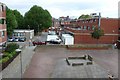
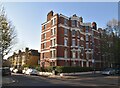
3
Hervey Court Battersea
Typical social housing of the 80's and 90's in London
Image: © Nigel Mykura
Taken: 4 Oct 2008
0.07 miles
4
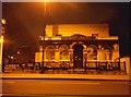
The Union Arms on Battersea Bridge Road
Image: © David Howard
Taken: 17 Mar 2014
0.09 miles
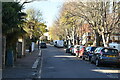
9
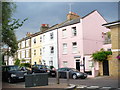
Octavia Street
Colourful row of three storey terraced houses, painted in pastel shades, in a middle class district near Battersea Park.
Image: © Colin Smith
Taken: 28 Jun 2009
0.14 miles