IMAGES TAKEN NEAR TO
Ivory Square, LONDON, SW11 3UE
Introduction
This page details the photographs taken nearby to Ivory Square, SW11 3UE by members of the Geograph project.
The Geograph project started in 2005 with the aim of publishing, organising and preserving representative images for every square kilometre of Great Britain, Ireland and the Isle of Man.

There are currently over 7.5m images from over14,400 individuals and you can help contribute to the project by visiting https://www.geograph.org.uk
Image Map
Images are licensed for reuse under creativecommons.org/licenses/by-sa/2.0
Notes
- Clicking on the map will re-center to the selected point.
- The higher the marker number, the further away the image location is from the centre of the postcode.
Image Listing (194 Images Found)
Images are licensed for reuse under creativecommons.org/licenses/by-sa/2.0
Image
Details
Distance
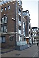
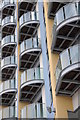
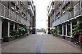
1
Coral Row
Part of the redevelopment of Battersea Reach
Image: © N Chadwick
Taken: 25 Aug 2010
0.01 miles
4
The Fish Place
Restaurant and apartments beside the Thames near Wandsworth Bridge.
Image: © Philip Halling
Taken: 24 Sep 2011
0.03 miles
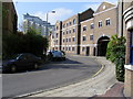
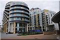
6
Plantation Wharf, Battersea Reach
Part of the extensive redevelopment of the Thames around Battersea.
Image: © N Chadwick
Taken: 25 Aug 2010
0.03 miles
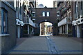
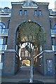
7
London : Battersea - Path between Apartments
A path from Gartons Way up towards the River Thames and river walk.
Image: © Lewis Clarke
Taken: 13 May 2011
0.03 miles
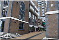
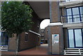
8
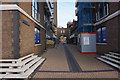
Coral Row
A route off Clove Hitch Quay in the Battersea Reach development which still shows ongoing construction work.
Image: © Bill Boaden
Taken: 11 Oct 2015
0.03 miles