IMAGES TAKEN NEAR TO
Square Rigger Row, LONDON, SW11 3TZ
Introduction
This page details the photographs taken nearby to Square Rigger Row, SW11 3TZ by members of the Geograph project.
The Geograph project started in 2005 with the aim of publishing, organising and preserving representative images for every square kilometre of Great Britain, Ireland and the Isle of Man.

There are currently over 7.5m images from over14,400 individuals and you can help contribute to the project by visiting https://www.geograph.org.uk
Image Map
Images are licensed for reuse under creativecommons.org/licenses/by-sa/2.0
Notes
- Clicking on the map will re-center to the selected point.
- The higher the marker number, the further away the image location is from the centre of the postcode.
Image Listing (198 Images Found)
Images are licensed for reuse under creativecommons.org/licenses/by-sa/2.0
Image
Details
Distance
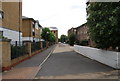
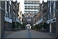
2
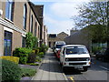
York Place
Plantation Wharf is on the left and Homebase is on the right
Image: © PAUL FARMER
Taken: 19 Apr 2009
0.02 miles
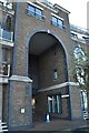
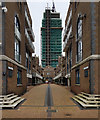
3
Cinnamon Row, Battersea SW11
Part of the Plantation Wharf complex
Image: © Alexander P Kapp
Taken: 26 Dec 2007
0.03 miles
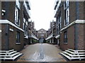
4
Cinnamon Row
Cinnamon Row in Battersea.
Image: © Peter McDermott
Taken: 7 Mar 2020
0.03 miles
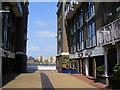
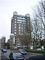
5
York Place
Part of a riverside development along Battersea Reach.
Image: © N Chadwick
Taken: 25 Aug 2010
0.04 miles
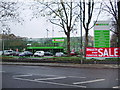
9
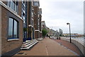
Redeveloped Waterfront, Battersea Reach
The whole south bank has been redeveloped along Battersea Reach.
Image: © N Chadwick
Taken: 25 Aug 2010
0.05 miles