IMAGES TAKEN NEAR TO
Granfield Street, LONDON, SW11 3JQ
Introduction
This page details the photographs taken nearby to Granfield Street, SW11 3JQ by members of the Geograph project.
The Geograph project started in 2005 with the aim of publishing, organising and preserving representative images for every square kilometre of Great Britain, Ireland and the Isle of Man.

There are currently over 7.5m images from over14,400 individuals and you can help contribute to the project by visiting https://www.geograph.org.uk
Image Map
Images are licensed for reuse under creativecommons.org/licenses/by-sa/2.0
Notes
- Clicking on the map will re-center to the selected point.
- The higher the marker number, the further away the image location is from the centre of the postcode.
Image Listing (175 Images Found)
Images are licensed for reuse under creativecommons.org/licenses/by-sa/2.0
Image
Details
Distance
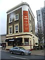
5
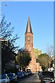
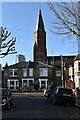
Church of The Sacred Heart
Grade II listed.
Image: © N Chadwick
Taken: 28 Nov 2021
0.07 miles
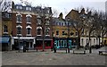
6
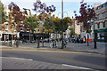
Battersea Square
A small retail enclave which includes opportunities for eating and drinking.
Image: © Bill Boaden
Taken: 11 Oct 2015
0.07 miles
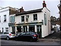
8

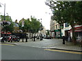
The Stag, Westbridge Road
At time of taking picture the pub was closed and occupied by property guardians
Image: © PAUL FARMER
Taken: 25 Feb 2017
0.07 miles