IMAGES TAKEN NEAR TO
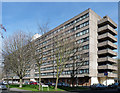
Meyrick Road, LONDON, SW11 2EF
Introduction
This page details the photographs taken nearby to Meyrick Road, SW11 2EF by members of the Geograph project.
The Geograph project started in 2005 with the aim of publishing, organising and preserving representative images for every square kilometre of Great Britain, Ireland and the Isle of Man.

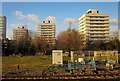
There are currently over 7.5m images from over14,400 individuals and you can help contribute to the project by visiting https://www.geograph.org.uk
Image Map
Images are licensed for reuse under creativecommons.org/licenses/by-sa/2.0
Notes
- Clicking on the map will re-center to the selected point.
- The higher the marker number, the further away the image location is from the centre of the postcode.
Image Listing (320 Images Found)
Images are licensed for reuse under creativecommons.org/licenses/by-sa/2.0
Image
Details
Distance
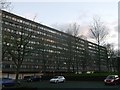
1
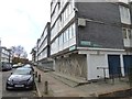
York Road Estate, Darien Road
Holcroft House, one of a pair of huge slabs facing each other across a stretch of green space. The estate dates from 1967-72 and was designed by Howes Jackman & Partners, and William Ryder & Associates, for Wandsworth Council.
Image: © Stephen Richards
Taken: 25 Mar 2012
0.02 miles
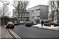
2
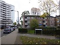
Flats in Livingstone Road, Clapham
Seen from the junction with Winstanley Road
Image: © David Smith
Taken: 17 Nov 2016
0.05 miles
3
Scholey House, Battersea
One of the seven blocks of housing on the York Estate.
As seen from Ingrave Street.
Image: © David Anstiss
Taken: 9 Dec 2012
0.06 miles
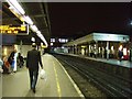
4
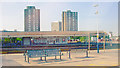
Clapham Junction Station, looking northwest from a local train
View west from a train on the Down Local platform 8 across platforms 1 - 7, with Peninsula Heights tower-blocks on the Albert Embankment.
Image: © Ben Brooksbank
Taken: 24 Jul 2008
0.06 miles
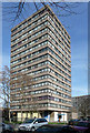
5
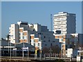
Flats on Winstanley Estate
Three 11-storey blocks of 44 flats; the nearest is Sendall Court, then Shaw Court, with Clarke Lawrence Court the furthest from the camera. On the extreme left is the taller Sportle Court. All four blocks date from the mid-1960s.
Image: © Derek Harper
Taken: 6 Feb 2015
0.06 miles
6
Winstanley Road
Central road in the Winstanley Estate.
Image: © Martin Addison
Taken: 19 Jan 2013
0.06 miles
7
York Road Estate, Lavender Road
Chesterton House, one of the estate's two point blocks. The estate dates from 1967-72 and was designed by Howes Jackman & Partners, and William Ryder & Associates, for Wandsworth Council.
Image: © Stephen Richards
Taken: 25 Mar 2012
0.08 miles
9
Abstract art on apartment block, Fenner Square
Image: © David Smith
Taken: 17 Nov 2016
0.09 miles
10
Little boxes, Clapham Junction
New residential development overlooking Clapham Junction Station.
Image: © Jim Osley
Taken: 2 Jan 2015
0.09 miles