
IMAGES TAKEN NEAR TO
Chelsea Crescent, Chelsea Harbour, LONDON, SW10 0XB
Introduction
This page details the photographs taken nearby to Chelsea Crescent, Chelsea Harbour, SW10 0XB by members of the Geograph project.
The Geograph project started in 2005 with the aim of publishing, organising and preserving representative images for every square kilometre of Great Britain, Ireland and the Isle of Man.

There are currently over 7.5m images from over14,400 individuals and you can help contribute to the project by visiting https://www.geograph.org.uk
Image Map
Images are licensed for reuse under creativecommons.org/licenses/by-sa/2.0
Notes
- Clicking on the map will re-center to the selected point.
- The higher the marker number, the further away the image location is from the centre of the postcode.
Image Listing (320 Images Found)
Images are licensed for reuse under creativecommons.org/licenses/by-sa/2.0
Image
Details
Distance
1

Footpath
Leading onto Harbour Avenue from the Thames Path
Image: © Alexander P Kapp
Taken: 19 Sep 2009
0.00 miles
2
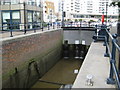
Chelsea Harbour Lock
The lock leading into the former Chelsea Basin has been here for a long time, certainly since 1869, when it is shown on the Ordnance Survey maps of that year. Today the basin is a marina and the square holes in the lock gates allow excess water to drain out of the marina into the lock at low tide.
Image: © Nigel Cox
Taken: 22 Jun 2008
0.02 miles
3
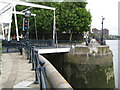
Chelsea Harbour lock bridge
This is the entrance into Chelsea Harbour through Image from the River Thames. The bridge is, I think, a bascule bridge, like Tower Bridge, in that it is one where the bridge deck pivots about a horizontal axis with a counterweight on the other side. Note the traffic lights controlling boat movements into and out of the lock!
Image: © Nigel Cox
Taken: 22 Jun 2008
0.02 miles
4

Belvedere, Chelsea Harbour
Belvedere and Chelsea Harbour viewed from across the River Thames.
Image: © Philip Halling
Taken: 24 Sep 2011
0.02 miles
5

Yacht club, Chelsea Harbour
The Riverside Walkway, from which this is taken, runs alongside the harbour development. Behind the yacht club rises Chelsea Crescent.
Image: © Derek Harper
Taken: 14 Oct 2006
0.02 miles
6

Belvedere, Chelsea Harbour
The 20-storey tower, built in the 1980s, overlooks the marina beside the Thames.
Image: © Derek Harper
Taken: 14 Oct 2006
0.03 miles
7
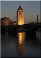
Belvedere, Chelsea Harbour
A view of Image reflecting the morning sun, taken from Regent Wharf, across the Thames, with the Cremorne Bridge carrying the West London Line.
Image: © Derek Harper
Taken: 16 Nov 2007
0.03 miles

9

Thames scene
The near boats are moored at Battersea Reach, Putney Railway Bridge crossing the Thames and Chelsea Harbour on the other side of the river.
Image: © Eirian Evans
Taken: 16 Aug 2013
0.03 miles
