IMAGES TAKEN NEAR TO
Burnaby Street, LONDON, SW10 0PP
Introduction
This page details the photographs taken nearby to Burnaby Street, SW10 0PP by members of the Geograph project.
The Geograph project started in 2005 with the aim of publishing, organising and preserving representative images for every square kilometre of Great Britain, Ireland and the Isle of Man.

There are currently over 7.5m images from over14,400 individuals and you can help contribute to the project by visiting https://www.geograph.org.uk
Image Map
Images are licensed for reuse under creativecommons.org/licenses/by-sa/2.0
Notes
- Clicking on the map will re-center to the selected point.
- The higher the marker number, the further away the image location is from the centre of the postcode.
Image Listing (307 Images Found)
Images are licensed for reuse under creativecommons.org/licenses/by-sa/2.0
Image
Details
Distance
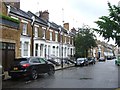
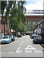
2
Burnaby Street
A terrace of houses, with blocks in the World's End Estate, dating from 1977, in the background.
Image: © Ian Capper
Taken: 6 May 2010
0.02 miles
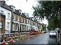
4
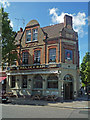
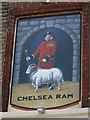
Chelsea Ram
A Youngs pub at the junction of Uverdale Road with Burnaby Street. The sign depicts a Chelsea Pensioner with a ram.
Image: © Ian Capper
Taken: 6 May 2010
0.03 miles
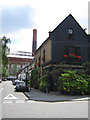
8
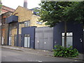
Converted Industrial Buildings 35 Tadama Road
Image: © PAUL FARMER
Taken: 26 Jun 2009
0.04 miles