IMAGES TAKEN NEAR TO
Harbour Avenue, LONDON, SW10 0HQ
Introduction
This page details the photographs taken nearby to Harbour Avenue, SW10 0HQ by members of the Geograph project.
The Geograph project started in 2005 with the aim of publishing, organising and preserving representative images for every square kilometre of Great Britain, Ireland and the Isle of Man.

There are currently over 7.5m images from over14,400 individuals and you can help contribute to the project by visiting https://www.geograph.org.uk
Image Map (Loading...)


Getting Data...Please wait
Leaflet Map data © OpenStreetMap
Images are licensed for reuse under creativecommons.org/licenses/by-sa/2.0
Notes
- Clicking on the map will re-center to the selected point.
- The higher the marker number, the further away the image location is from the centre of the postcode.
Image Listing (277 Images Found)
Images are licensed for reuse under creativecommons.org/licenses/by-sa/2.0
Image
Details
Distance
1
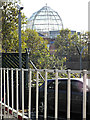
Glass dome at Chelsea Harbour
One of several at the Design Centre. Viewed from Lots Road.
Image: © Thomas Nugent
Taken: 8 Oct 2014
0.01 miles
2
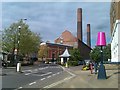
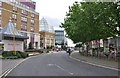
Harbour Avenue looking towards Lots Road power station
Image: © David Martin
Taken: 16 May 2012
0.01 miles
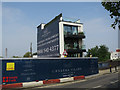
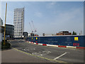
4
Lots Road Power Station development
First built in 1904 and decommissioned in 2002. One of London's major developments will have over 700 flats when finished.
Image: © James Emmans
Taken: 28 May 2022
0.01 miles
5
London : Chelsea - Harbour Avenue
Harbour Avenue in Chelsea is close to the border with Battersea and Wandsworth.
Image: © Lewis Clarke
Taken: 13 May 2011
0.02 miles
6
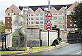
Chelsea Harbour Drive
The bridge crosses Chelsea Creek.
Image: © Thomas Nugent
Taken: 8 Oct 2014
0.02 miles
7
Chelsea Island site
By Chelsea Harbour.
Image: © Hugh Venables
Taken: 28 May 2016
0.02 miles
8

"Gateway of Hands"
A sculpture by Glynn Williams, commissioned in 1993, and sited opposite Chelsea Harbour Design Centre on Harbour Avenue.
Image: © Derek Harper
Taken: 14 Oct 2006
0.02 miles
9
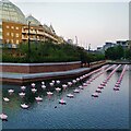
View of Aether & Hemera's 'Voyage' at Chelsea Creek Basin
Voyage - Conceived and created by art and design studio Aether & Hemera.
A flotilla of origami boats on the Chelsea Creek basin invites everyone to make a transition from reality to imagination.
Image: © J W
Taken: 3 Sep 2021
0.02 miles
10
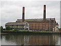
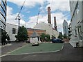
Chelsea: Former Lots Road power station
Lots Road power station was completed in 1905 to provide electricity to the Metropolitan District Railway, later London Underground's District Line. When it was built it was claimed to be the largest power station in the world. It originally had four chimney stacks, but two were demolished when it was converted to run on fuel oil instead of coal in the 1960s. It has been completely re-equipped on several occasions, as technology has moved on, but a decision was made by London Underground in the 1990s not to maintain it any more and let the equipment become time-expired. It eventually ceased operations in 2002, and has been decommissioned. It is now the subject of a major refurbishment scheme to see it converted into new offices, housing and shops.
This view was taken from across the River Thames in Battersea.
From a Geograph point of view the 177000 Northing grid line runs diagonally through the middle of the main building between the chimneys, but the smaller grey building is entirely in this grid square, hence the allocation. Some other images of it from different vantage points may correctly be found in Image
Image: © Nigel Cox
Taken: 28 May 2008
0.03 miles