IMAGES TAKEN NEAR TO
Armshead Road, STOKE-ON-TRENT, ST9 0ND
Introduction
This page details the photographs taken nearby to Armshead Road, ST9 0ND by members of the Geograph project.
The Geograph project started in 2005 with the aim of publishing, organising and preserving representative images for every square kilometre of Great Britain, Ireland and the Isle of Man.

There are currently over 7.5m images from over14,400 individuals and you can help contribute to the project by visiting https://www.geograph.org.uk
Image Map
Images are licensed for reuse under creativecommons.org/licenses/by-sa/2.0
Notes
- Clicking on the map will re-center to the selected point.
- The higher the marker number, the further away the image location is from the centre of the postcode.
Image Listing (6 Images Found)
Images are licensed for reuse under creativecommons.org/licenses/by-sa/2.0
Image
Details
Distance
1
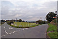
Junction on Armshead Road
The fence creates a stock proof boundary but allows a good view for traffic using the junction. To the right, Armshead Road continues to Longsdon. To the left is Luzlow Lane, which leads to Bagnall, Stanley and Endon.
Image: © Richard Dorrell
Taken: 20 Sep 2014
0.08 miles
2
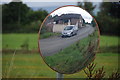
Reflection of car in mirror
Had to zoom in to get this from across the road.
Image: © Stu JP
Taken: 24 Aug 2010
0.16 miles
3
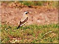
Wheatear in field
Caught this Wheatear hopping about on Wetley Moor Common.
Image: © Stu JP
Taken: 21 Apr 2011
0.17 miles
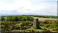
4
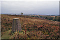
Wetley Moor trig point
Looking south west past the trig point.
Image: © Richard Dorrell
Taken: 20 Sep 2014
0.24 miles
5
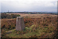
Wetley Moor trig point
Looking north west past the trig point.
Image: © Richard Dorrell
Taken: 20 Sep 2014
0.25 miles