IMAGES TAKEN NEAR TO
Southlowe Road, STOKE-ON-TRENT, ST9 0HR
Introduction
This page details the photographs taken nearby to Southlowe Road, ST9 0HR by members of the Geograph project.
The Geograph project started in 2005 with the aim of publishing, organising and preserving representative images for every square kilometre of Great Britain, Ireland and the Isle of Man.

There are currently over 7.5m images from over14,400 individuals and you can help contribute to the project by visiting https://www.geograph.org.uk
Image Map
Images are licensed for reuse under creativecommons.org/licenses/by-sa/2.0
Notes
- Clicking on the map will re-center to the selected point.
- The higher the marker number, the further away the image location is from the centre of the postcode.
Image Listing (6 Images Found)
Images are licensed for reuse under creativecommons.org/licenses/by-sa/2.0
Image
Details
Distance
1
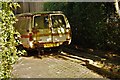
Disused Vehicle
Morris van rotting away in a driveway on Southlowe Avenue.
Image: © Stu JP
Taken: 10 Mar 2015
0.05 miles
2
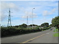
Electricity pylons at Withystakes
Two electricity transmission lines crossing the A52.
Image: © David Weston
Taken: 1 Sep 2016
0.15 miles
3
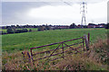
Pastureland at Withystakes
Viewed over a gate from Rownhall Road.
Image: © Richard Dorrell
Taken: 20 Sep 2014
0.15 miles
4
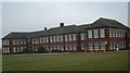
Moorside High School, Cellarhead
Moorside High School is based in Cellarhead, Werrington. It has around 800 students aged between 11-18.
Image: © Steven Birks
Taken: 17 Feb 2007
0.17 miles
5
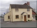
Old Toll House by Armshead Road, Withystakes
Withystakes Toll House by the UC road (was A52), in parish of Werrington (Staffordshire Moorlands District), Tollbar Cottage, Withystakes, Armshead Road, ST9 0HL.
Staffordshire HER.
HER Number: 55862 https://www.heritagegateway.org.uk/Gateway/Results_Single.aspx?uid=MST19979&resourceID=1010
Surveyed
Milestone Society National ID: ST.WER
Image: © Milestone Society
Taken: Unknown
0.20 miles
6
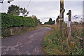
Track to The Waste
Viewed from its start from Rownhall Road. The track is also a public footpath, and provides access to a number of farms and dwellings in an area named 'The Waste'.
Image: © Richard Dorrell
Taken: 20 Sep 2014
0.23 miles