IMAGES TAKEN NEAR TO
Russell Grove, STOKE-ON-TRENT, ST9 0EX
Introduction
This page details the photographs taken nearby to Russell Grove, ST9 0EX by members of the Geograph project.
The Geograph project started in 2005 with the aim of publishing, organising and preserving representative images for every square kilometre of Great Britain, Ireland and the Isle of Man.

There are currently over 7.5m images from over14,400 individuals and you can help contribute to the project by visiting https://www.geograph.org.uk
Image Map
Images are licensed for reuse under creativecommons.org/licenses/by-sa/2.0
Notes
- Clicking on the map will re-center to the selected point.
- The higher the marker number, the further away the image location is from the centre of the postcode.
Image Listing (15 Images Found)
Images are licensed for reuse under creativecommons.org/licenses/by-sa/2.0
Image
Details
Distance
1
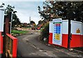
Demolition of Werrington Primary School
Lovell Partnership Ltd make plans to build 31 homes on this derelict piece of land. Workmen and two excavators can be seen in the background.
Image: © Stu JP
Taken: 8 Oct 2015
0.06 miles
2

Mary Poppins & Bert - Werrington Scarecrow Weekend 2015
One of 32 scarecrows designed by people in the Werrington community.
Image: © Stu JP
Taken: 12 Sep 2015
0.10 miles

4
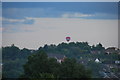
Hot Air Balloon
Flying over the semi-rural village of Werrington just before sunset.
These leisure events usually launch from Trentham Gardens.
Image: © Stu JP
Taken: 22 Jul 2015
0.15 miles
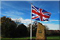
5

Werrington Poppy Man in Staffordshire (British Legion Poppy Appeal)
The Werrington Poppy Man Project was launched today to mark the beginning of the British Legion Poppy Appeal.
The figure is made entirely from plastic bottles (except the head of course!) and there is also a knitted wreath on the bench next to the Poppy Man.
Image: © Stu JP
Taken: 23 Oct 2015
0.15 miles
7
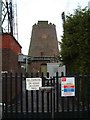
Windmill, Werrington
Standing on the highest point of the village of Werrington is the Old Windmill. It is said to date from 1730.
The last miller was Mark Greatbatch who is listed in White's Gazetteer of 1851.
Towards the end of its life it was used for grinding coal for the manufacture of 'brickettes'
In the grounds is a transmission mast and nearby is The Windmill public house:- http://www.geograph.org.uk/photo/340367
Image: © Steven Birks
Taken: 17 Feb 2007
0.16 miles
8
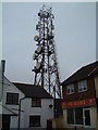
Transmission Tower, Werrington
Situated on the highest point in Werrington sits this transmission tower. It is in the grounds of an old windmill:-
http://www.geograph.org.uk/photo/341006
Image: © Steven Birks
Taken: 17 Feb 2007
0.19 miles
9
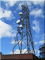
Transmission tower at Werrington
The transmission tower is next to the remains of a windmill, part of which is on the right here. They share the same secured grounds.
Image: © David Weston
Taken: 22 Sep 2013
0.20 miles
10
Windmill at Werrington
The windmill is next to a transmission tower, part of which is on the left here. They share the same secured grounds. (The camera is looking between the gaps of a metal gate.)
Image: © David Weston
Taken: 22 Sep 2013
0.20 miles