IMAGES TAKEN NEAR TO
Biddulph Park Road, STOKE-ON-TRENT, ST8 7SJ
Introduction
This page details the photographs taken nearby to Biddulph Park Road, ST8 7SJ by members of the Geograph project.
The Geograph project started in 2005 with the aim of publishing, organising and preserving representative images for every square kilometre of Great Britain, Ireland and the Isle of Man.

There are currently over 7.5m images from over14,400 individuals and you can help contribute to the project by visiting https://www.geograph.org.uk
Image Map
Images are licensed for reuse under creativecommons.org/licenses/by-sa/2.0
Notes
- Clicking on the map will re-center to the selected point.
- The higher the marker number, the further away the image location is from the centre of the postcode.
Image Listing (10 Images Found)
Images are licensed for reuse under creativecommons.org/licenses/by-sa/2.0
Image
Details
Distance
1

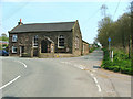
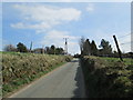
Up Biddulph Park Road
Looking up Biddulph Park Road from its junction with Troughstone Road. The building on the right is Chapel Cottage, attached to Image
Image: © Jonathan Kington
Taken: 3 Nov 2010
0.08 miles
2
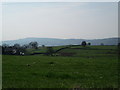
View from Biddulph Common Road
Countryside north-east of Biddulph. In the blue haze in the distance is Congleton Edge.
Image: © David Weston
Taken: 8 Apr 2015
0.18 miles
3
Towards Biddulph Park
Looking along Troughstone Road to its junction with Biddulph Park Road near the Methodist Chapel (Image).
Image: © Jonathan Kington
Taken: 3 Nov 2010
0.18 miles
4
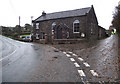
The Chapel on the corner
Biddulph Park Methodist Chapel sits on the corner of Biddulph Park Road where Troughstone Road joins it. For a similar view taken in 2006 by Neil Lewin see Image and although little looks to have changed, the front boundary wall has been replaced after a car accident a couple of years ago.
Image: © Jonathan Kington
Taken: 3 Nov 2010
0.18 miles
5
Biddulph Park Methodist Chapel
Established in 1860. The left hand part of the building is a private dwelling, not surprisingly called Chapel Cottage.
Image: © Neil Lewin
Taken: 4 May 2006
0.18 miles
6
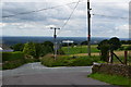
Biddulph Common Road
Looking towards the crossroads at Newtown. The road is bordered by banks made of stone and turf, which seem to be very old.
Image: © David Weston
Taken: 8 Apr 2015
0.21 miles
7
Crossroads at Newtown
Looking along Long Edge Road towards the crossroads. In the blue haze in the distance is Congleton Edge.
Image: © David Weston
Taken: 8 Apr 2015
0.21 miles
8
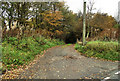
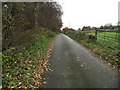
Start of the path
This is the start of the public footpath that takes you down to Overton Road and/or Hurst Road, it is also the start of the farm lane that goes to Moor House Farm. The picture was taken from the junction of Troughstone Road and Biddulph Park Road, opposite Image
Image: © Jonathan Kington
Taken: 3 Nov 2010
0.22 miles
9
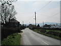
Road junction by Park farm
Taken from the end of Newtown Road.
Image: © Trevor Harris
Taken: 13 Jul 2016
0.23 miles
10
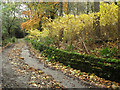
Looking back up the track
Looking back up the public footpath that is also the lane that leads to Moor House Farm.
Image: © Jonathan Kington
Taken: 3 Nov 2010
0.25 miles