IMAGES TAKEN NEAR TO
Bemersley Road, STOKE-ON-TRENT, ST8 7QT
Introduction
This page details the photographs taken nearby to Bemersley Road, ST8 7QT by members of the Geograph project.
The Geograph project started in 2005 with the aim of publishing, organising and preserving representative images for every square kilometre of Great Britain, Ireland and the Isle of Man.

There are currently over 7.5m images from over14,400 individuals and you can help contribute to the project by visiting https://www.geograph.org.uk
Image Map
Images are licensed for reuse under creativecommons.org/licenses/by-sa/2.0
Notes
- Clicking on the map will re-center to the selected point.
- The higher the marker number, the further away the image location is from the centre of the postcode.
Image Listing (11 Images Found)
Images are licensed for reuse under creativecommons.org/licenses/by-sa/2.0
Image
Details
Distance
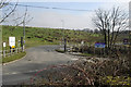
1
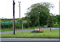
Bemersley Green
Behind can be seen Bemersley Household Waste and Recycling Depot. The road opposite goes to Greenway Bank Country Park and Knypersley reservoir.
Image: © Neil Lewin
Taken: 25 Aug 2006
0.07 miles
2
Stone circle
Somebody has created this stone circle, presumably as a point of interest rather than for historical value. The notice board is very informative with lots of interesting facts and pictures about the development of Brindley Meadow.
The 11.8 hectare Brindley Meadow started life in the 19th century as a sandstone quarry known as Knypersley Quarry. In later years it became a dumping ground for slag from a nearby foundry and for shale from local mining activities, this was to continue until the site was abandoned and left derelict in the 1960’s. In the mid-1990’s a development company, Banks Group ( http://www.banksgroup.co.uk/ ), became involved and applied for, and secured, planning permission to reclaim the quarry. This involved the extraction of coal from underneath the quarry between 1997 and 1999 and the tipping of 250,000 tonnes of inert material into the quarry between 2000 and 2002, with the final reclamation finished in the same year. Approximately 50% of the site is planted with trees to create woodland, the rest with wildflowers and shrubs.
Image: © Jonathan Kington
Taken: 3 Mar 2011
0.12 miles
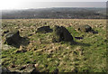
3
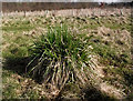
Grass tussock
Grass tussocks, such as this one on Brindley Meadow, are an important habitat for burrowing insects. They provide a safe haven from predators and extremes in weather. Many of the invertebrates will lay their eggs in the middle of tussock where the temperature remains fairly stable.
The 11.8 hectare Brindley Meadow started life in the 19th century as a sandstone quarry known as Knypersley Quarry. In later years it became a dumping ground for slag from a nearby foundry and for shale from local mining activities, this was to continue until the site was abandoned and left derelict in the 1960’s. In the mid-1990’s a development company, Banks Group ( http://www.banksgroup.co.uk/ ), became involved and applied for, and secured, planning permission to reclaim the quarry. This involved the extraction of coal from underneath the quarry between 1997 and 1999 and the tipping of 250,000 tonnes of inert material into the quarry between 2000 and 2002, with the final reclamation finished in the same year. Approximately 50% of the site is planted with trees to create woodland, the rest with wildflowers and shrubs.
Image: © Jonathan Kington
Taken: 3 Mar 2011
0.14 miles
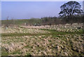
4
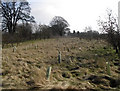
Shrub belt
On the right and left of the picture trees such as Alder, Ash, Rowan, Cherry and Oak have been planted to create new woodland. Shrubs such as Hawthorn, Hazel, Guelder Rose, Dog Wood and Willow have been planted through the centre.
The 11.8 hectare Brindley Meadow started life in the 19th century as a sandstone quarry known as Knypersley Quarry. In later years it became a dumping ground for slag from a nearby foundry and for shale from local mining activities, this was to continue until the site was abandoned and left derelict in the 1960’s. In the mid-1990’s a development company, Banks Group ( http://www.banksgroup.co.uk/ ), became involved and applied for, and secured, planning permission to reclaim the quarry. This involved the extraction of coal from underneath the quarry between 1997 and 1999 and the tipping of 250,000 tonnes of inert material into the quarry between 2000 and 2002, with the final reclamation finished in the same year. Approximately 50% of the site is planted with trees to create woodland, the rest with wildflowers and shrubs.
Image: © Jonathan Kington
Taken: 3 Mar 2011
0.15 miles
5
To the tip
The entrance to the Waste Transfer Site as the map politely calls it or Bemersley Refuse Tip as the sign pronounces it.
Image: © Jonathan Kington
Taken: 3 Mar 2011
0.17 miles
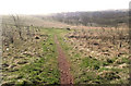
6
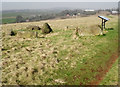
Path junction
The path ahead leads from the top path on Brindley Meadow and comes out on Bemersley Road opposite the entrance to the waste transfer site.
The 11.8 hectare Brindley Meadow started life in the 19th century as a sandstone quarry known as Knypersley Quarry. In later years it became a dumping ground for slag from a nearby foundry and for shale from local mining activities, this was to continue until the site was abandoned and left derelict in the 1960’s. In the mid-1990’s a development company, Banks Group ( http://www.banksgroup.co.uk/ ), became involved and applied for, and secured, planning permission to reclaim the quarry. This involved the extraction of coal from underneath the quarry between 1997 and 1999 and the tipping of 250,000 tonnes of inert material into the quarry between 2000 and 2002, with the final reclamation finished in the same year. Approximately 50% of the site is planted with trees to create woodland, the rest with wildflowers and shrubs.
Image: © Jonathan Kington
Taken: 3 Mar 2011
0.17 miles
7
Across the meadow
Looking from the north-eastern entrance to Brindley Meadow to Brindley Ford in the bottom of the valley.
The 11.8 hectare Brindley Meadow started life in the 19th century as a sandstone quarry known as Knypersley Quarry. In later years it became a dumping ground for slag from a nearby foundry and for shale from local mining activities, this was to continue until the site was abandoned and left derelict in the 1960’s. In the mid-1990’s a development company, Banks Group ( http://www.banksgroup.co.uk/ ), became involved and applied for, and secured, planning permission to reclaim the quarry. This involved the extraction of coal from underneath the quarry between 1997 and 1999 and the tipping of 250,000 tonnes of inert material into the quarry between 2000 and 2002, with the final reclamation finished in the same year. Approximately 50% of the site is planted with trees to create woodland, the rest with wildflowers and shrubs.
Image: © Jonathan Kington
Taken: 3 Mar 2011
0.21 miles
8
Towards Brindley Ford
Looking down across Brindley Meadow to the rooftops of the houses in Brindley Ford.
The 11.8 hectare Brindley Meadow started life in the 19th century as a sandstone quarry known as Knypersley Quarry. In later years it became a dumping ground for slag from a nearby foundry and for shale from local mining activities, this was to continue until the site was abandoned and left derelict in the 1960’s. In the mid-1990’s a development company, Banks Group ( http://www.banksgroup.co.uk/ ), became involved and applied for, and secured, planning permission to reclaim the quarry. This involved the extraction of coal from underneath the quarry between 1997 and 1999 and the tipping of 250,000 tonnes of inert material into the quarry between 2000 and 2002, with the final reclamation finished in the same year. Approximately 50% of the site is planted with trees to create woodland, the rest with wildflowers and shrubs.
Image: © Jonathan Kington
Taken: 3 Mar 2011
0.21 miles
9
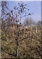
Common Alder on Brindley Meadow
The Common Alder (Alnus glutinosa) is a common tree that can be found just about anywhere although its preferred habitat is normally in clumps on riversides (riparian). They are excellent trees for increasing the fertility of soil due to its ability to fix nitrogen from the air through its leaves. Alders are a member of the Birch family and as such are considered ‘pioneer’ plants, growing quickly but not living for long- typically about 150 years. They will grow to a maximum of 25 metres with an annual growth of up 90 cm a year. The Alder is monoecious, or asexual, with each tree carrying both male and female flowers. The male flowers come in the form of dark-yellow catkins up to 5 cm long; the female flowers are in the shape of a red conifer-like cone and are up to 6 mm in size.
The 11.8 hectare Brindley Meadow started life in the 19th century as a sandstone quarry known as Knypersley Quarry. In later years it became a dumping ground for slag from a nearby foundry and for shale from local mining activities, this was to continue until the site was abandoned and left derelict in the 1960’s. In the mid-1990’s a development company, Banks Group ( http://www.banksgroup.co.uk/ ), became involved and applied for, and secured, planning permission to reclaim the quarry. This involved the extraction of coal from underneath the quarry between 1997 and 1999 and the tipping of 250,000 tonnes of inert material into the quarry between 2000 and 2002, with the final reclamation finished in the same year. Approximately 50% of the site is planted with trees to create woodland, the rest with wildflowers and shrubs.
Image: © Jonathan Kington
Taken: 3 Mar 2011
0.22 miles
10
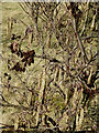
Cones and catkins
Showing the female cones and male catkins on the Image
The Common Alder (Alnus glutinosa) is a common tree that can be found just about anywhere although its preferred habitat is normally in clumps on riversides (riparian). They are excellent trees for increasing the fertility of soil due to its ability to fix nitrogen from the air through its leaves. Alders are a member of the Birch family and as such are considered ‘pioneer’ plants, growing quickly but not living for long- typically about 150 years. They will grow to a maximum of 25 metres with an annual growth of up 90 cm a year. The Alder is monoecious, or asexual, with each tree carrying both male and female flowers. The male flowers come in the form of dark-yellow catkins up to 5 cm long; the female flowers are in the shape of a red conifer-like cone and are up to 6 mm in size.
The 11.8 hectare Brindley Meadow started life in the 19th century as a sandstone quarry known as Knypersley Quarry. In later years it became a dumping ground for slag from a nearby foundry and for shale from local mining activities, this was to continue until the site was abandoned and left derelict in the 1960’s. In the mid-1990’s a development company, Banks Group ( http://www.banksgroup.co.uk/ ), became involved and applied for, and secured, planning permission to reclaim the quarry. This involved the extraction of coal from underneath the quarry between 1997 and 1999 and the tipping of 250,000 tonnes of inert material into the quarry between 2000 and 2002, with the final reclamation finished in the same year. Approximately 50% of the site is planted with trees to create woodland, the rest with wildflowers and shrubs.
Image: © Jonathan Kington
Taken: 3 Mar 2011
0.22 miles