IMAGES TAKEN NEAR TO
Mill Hayes Road, STOKE-ON-TRENT, ST8 7PS
Introduction
This page details the photographs taken nearby to Mill Hayes Road, ST8 7PS by members of the Geograph project.
The Geograph project started in 2005 with the aim of publishing, organising and preserving representative images for every square kilometre of Great Britain, Ireland and the Isle of Man.

There are currently over 7.5m images from over14,400 individuals and you can help contribute to the project by visiting https://www.geograph.org.uk
Image Map
Images are licensed for reuse under creativecommons.org/licenses/by-sa/2.0
Notes
- Clicking on the map will re-center to the selected point.
- The higher the marker number, the further away the image location is from the centre of the postcode.
Image Listing (15 Images Found)
Images are licensed for reuse under creativecommons.org/licenses/by-sa/2.0
Image
Details
Distance
1
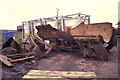
Colliery yard - Brown Lees opencast site, Biddulph
This site has now completely disappeared with the completion of the opencast mining. The new workings had encountered the old workings of the Victoria and Brindley Ford Collieries and at the bottom of a shaft were the remains of a steam winding/haulage engine. It was pretty soon realised by the traction engine fraternity that this had been converted from a very early chain drive Aveling and Porting engine. The motion is single cylinder. It has now been acquired for private conservation but i'm not sure what has become of it. It was displayed at several rallies, including a Great Dorset Steam Fair.
Image: © Chris Allen
Taken: 20 Feb 1993
0.13 miles
2

Business unit, Knypersley
Located in Prospect Way, this is the premises of Parker Software Limited.
Image: © Richard Dorrell
Taken: 8 Mar 2016
0.13 miles
3

Industrial Unit, Prospect Way
This is the premises of Bakers, a coach hire business offering vehicles seating from 29 to 57 passengers.
Image: © Richard Dorrell
Taken: 8 Mar 2016
0.14 miles
4

Victoria Business Park
Built on the site of the old Victoria colliery. I presume the spire at the entrance has mining undertones although I can't see it myself. Biddulph seem to enjoy obscure public art - see also SJ8857.
Image: © Neil Lewin
Taken: 25 Aug 2006
0.17 miles
5
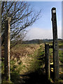
Footpath to Greenway Bank
This public footpath takes walkers from the junction of Childerplay Road and Bemersley Road along the edge of the reclaimed refuse tip on the right before emerging on Greenway Bank. The trees in the distance are on Greenway Bank Country Park.
Image: © Jonathan Kington
Taken: 3 Mar 2011
0.17 miles
6
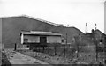
Black Bull Station (remains)
View westward, across the Biddulph Valley line (Stoke-on-Trent - Ford Green (left)- North Rode (right)). Station and line closed to passengers 11/7/27, but station not closed to goods until 6/1/64 and mineral trains ran over the line until 24/1/76. Behind are the Old Tips of Victoria Colliery, which closed in 8/82.
Image: © Ben Brooksbank
Taken: 20 Apr 1962
0.18 miles
7

Looking to the entrance
Looking back towards the north-eastern entrance to Brindley Meadow, emerging on the junction of Childerplay Road and Bemersley Road.
The 11.8 hectare Brindley Meadow started life in the 19th century as a sandstone quarry known as Knypersley Quarry. In later years it became a dumping ground for slag from a nearby foundry and for shale from local mining activities, this was to continue until the site was abandoned and left derelict in the 1960’s. In the mid-1990’s a development company, Banks Group ( http://www.banksgroup.co.uk/ ), became involved and applied for, and secured, planning permission to reclaim the quarry. This involved the extraction of coal from underneath the quarry between 1997 and 1999 and the tipping of 250,000 tonnes of inert material into the quarry between 2000 and 2002, with the final reclamation finished in the same year. Approximately 50% of the site is planted with trees to create woodland, the rest with wildflowers and shrubs.
Image: © Jonathan Kington
Taken: 3 Mar 2011
0.19 miles
8
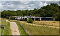
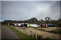
Lorry Park
Incongruous lorry park alongside the Biddulph Valley Way / Brindley Ford Greenway.
Image: © Peter McDermott
Taken: 13 Jul 2023
0.21 miles
9
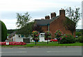
Victoria Row, Biddulph
A single terrace with a petrol station and car sales next door left, and fields to the right. Directly opposite the old Victoria Colliery site although I don't know if they are related.
Image: © Neil Lewin
Taken: 25 Aug 2006
0.21 miles