IMAGES TAKEN NEAR TO
New Street, STOKE-ON-TRENT, ST8 7NW
Introduction
This page details the photographs taken nearby to New Street, ST8 7NW by members of the Geograph project.
The Geograph project started in 2005 with the aim of publishing, organising and preserving representative images for every square kilometre of Great Britain, Ireland and the Isle of Man.

There are currently over 7.5m images from over14,400 individuals and you can help contribute to the project by visiting https://www.geograph.org.uk
Image Map
Images are licensed for reuse under creativecommons.org/licenses/by-sa/2.0
Notes
- Clicking on the map will re-center to the selected point.
- The higher the marker number, the further away the image location is from the centre of the postcode.
Image Listing (25 Images Found)
Images are licensed for reuse under creativecommons.org/licenses/by-sa/2.0
Image
Details
Distance
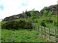
1
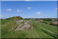
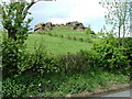
Wicken Stones, and watershed
A prominent ridge of gritstone outcrop on Biddulph Moor forms a significant watershed. On the right waters drain to the North sea via the Trent; on the left they drain to the Irish Sea.
Image: © Tim Heaton
Taken: 18 Apr 2018
0.05 miles
2
Entrance to Wickenstones Farm
Taken from its junction with New Street, before reaching the cattle grid there is a public footpath to the left that leads to Ruthin Grove (Image). On the right the gritstone outcrops of the Wickenstones can be seen with the top of the mobile phone mast just visible (see also Image).
Image: © Jonathan Kington
Taken: 20 Jul 2011
0.08 miles
3
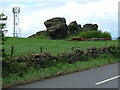
Wickenstones
The Wickenstones plus a discreet phone mast (just visible on the left of the photo)
Image: © Neil Lewin
Taken: 23 May 2006
0.08 miles
4
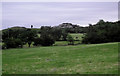
Across to the Wickenstones
Looking from the path junction near the top of Ruthin Grove across the fields to the massive Gritstone outcrops known as the Wickenstones.
Image: © Jonathan Kington
Taken: 28 Jun 2011
0.08 miles
5
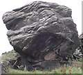
A closer look at one of the Wickenstones
This is a more detailed view using telephoto assistance of the huge gritstone boulder that appears in Image, to give an idea of scale the Foxglove plant in front of it is approximately 60cm (2 feet) high. The Wickenstones are a linear outcropping of Gritstone that some claim to be the most southerly point of the Pennine chain.
Image: © Jonathan Kington
Taken: 20 Jul 2011
0.10 miles
6
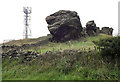
Wickenstones and mast
Another view of the Wickenstones with a mobile phone mast tucked away behind them, the boulders are part of a gritstone outcrop that some allege to be the southernmost point of the Pennine range. For a more detailed look at the nearest one see Image
Image: © Jonathan Kington
Taken: 20 Jul 2011
0.11 miles
7
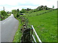
Wickenstones
A view of the Wickenstones with the road from Biddulph Moor to Knypersley
Image: © Neil Lewin
Taken: 23 May 2006
0.12 miles
8
Another of the Wickenstones
said by some to be the most Southern point of the Pennines
Image: © Neil Lewin
Taken: 23 May 2006
0.12 miles
9
How to fence off a rock outcrop
If you own it, mark it.
Image: © Neil Lewin
Taken: 23 May 2006
0.12 miles
10
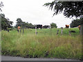
Grazing cattle
One or two of these cows showed an interest in me but the rest just kept contentedly grazing.
Image: © Jonathan Kington
Taken: 21 Jul 2011
0.14 miles