IMAGES TAKEN NEAR TO
Pennine Way, STOKE-ON-TRENT, ST8 7HF
Introduction
This page details the photographs taken nearby to Pennine Way, ST8 7HF by members of the Geograph project.
The Geograph project started in 2005 with the aim of publishing, organising and preserving representative images for every square kilometre of Great Britain, Ireland and the Isle of Man.

There are currently over 7.5m images from over14,400 individuals and you can help contribute to the project by visiting https://www.geograph.org.uk
Image Map
Images are licensed for reuse under creativecommons.org/licenses/by-sa/2.0
Notes
- Clicking on the map will re-center to the selected point.
- The higher the marker number, the further away the image location is from the centre of the postcode.
Image Listing (135 Images Found)
Images are licensed for reuse under creativecommons.org/licenses/by-sa/2.0
Image
Details
Distance
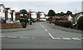
1
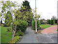
Path to Pennine Way
Looking along the path from Checkley Drive to Pennine Way, emerging opposite Ox-hey Drive. For an opposite view see Image
Image: © Jonathan Kington
Taken: 8 Sep 2010
0.01 miles
2
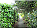
Path to Checkley Drive
Looking along the path from Pennine Way to Checkley Drive, an opposite view to Image
Image: © Jonathan Kington
Taken: 8 Sep 2010
0.01 miles
3
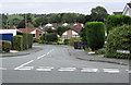
Looking up Checkley Drive
Checkley Drive from its junction with Pennine Way, in a more or less opposite view to Image
Image: © Jonathan Kington
Taken: 13 Sep 2010
0.01 miles
4
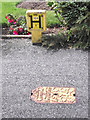
Fire hydrant
Located on the corner of Ox-Hey Drive and Pennine Way, the yellow post with a large black letter 'H' shows the distance to the hydrant and the size of the outlet; in this case it is a 100mm outlet located at a distance of 1 metre. The cover, also painted yellow, is a Stanton Warrior stamped STW denoting that the water supplier is Severn Trent Water.
Image: © Jonathan Kington
Taken: 7 Aug 2011
0.02 miles
5

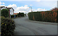
Checkley Drive
Looking north on Checkley Drive before it swings left to join Pennine Way.
Image: © Jonathan Kington
Taken: 8 Sep 2010
0.02 miles
6
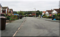
Down to Pennine Way
Looking down Checkley Drive to its junction with Pennine Way.
Image: © Jonathan Kington
Taken: 8 Sep 2010
0.02 miles
7
Sign for Dove Grove
The name sign for Image, at its junction with Pennine Way.
Image: © Jonathan Kington
Taken: 11 Aug 2010
0.03 miles
8
Down Dove Grove
Looking down Dove grove to its junction with Pennine Way, an opposite view to Image
Image: © Jonathan Kington
Taken: 13 Sep 2010
0.03 miles
9
Selectus land
This is the view across some of the land belonging to the Selectus factory Image If planning permission is granted, the factory will soon be closed and houses built here.
Image: © Jonathan Kington
Taken: 5 Jan 2010
0.05 miles
10
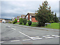
Tame Close
Taken from its junction with Pennine Way, Tame Close is typical of the cul-de-sacs that run off the southern side of Pennine Way.
Image: © Jonathan Kington
Taken: 13 Sep 2010
0.06 miles