IMAGES TAKEN NEAR TO
Woodland Street, STOKE-ON-TRENT, ST8 6LW
Introduction
This page details the photographs taken nearby to Woodland Street, ST8 6LW by members of the Geograph project.
The Geograph project started in 2005 with the aim of publishing, organising and preserving representative images for every square kilometre of Great Britain, Ireland and the Isle of Man.

There are currently over 7.5m images from over14,400 individuals and you can help contribute to the project by visiting https://www.geograph.org.uk
Image Map
Images are licensed for reuse under creativecommons.org/licenses/by-sa/2.0
Notes
- Clicking on the map will re-center to the selected point.
- The higher the marker number, the further away the image location is from the centre of the postcode.
Image Listing (6 Images Found)
Images are licensed for reuse under creativecommons.org/licenses/by-sa/2.0
Image
Details
Distance
1
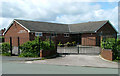
Kingdom Hall of Jehovah's Witnesses
Situated on the corner of Church Road and Church Close, this was allegedly erected in one day by worshippers.
Image: © Neil Lewin
Taken: 23 May 2006
0.10 miles
2

St John's Roundabout
These lights, which glow blue, may be based on miners lamps as this is an ex-miners estate, or may have a police link as the flats behind the roundabout are built on the site of the police station. No-one seems to be sure.
Image: © Neil Lewin
Taken: 23 May 2006
0.14 miles
3
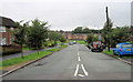
Looking down St John's Road
Looking down St John's Road from its junction with Lawton Street, Cornfield Road and Kingsfield Road. Part of Image (ccl Neil Lewin) can be seen at the bottom.
Image: © Jonathan Kington
Taken: 10 Sep 2010
0.19 miles
4
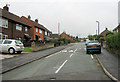
Springfield Road
Looking up Springfield Road from its junction with Cornfield Road, Lawton Street and St John's Road. The junction with Duke Street can be seen on the left.
Image: © Jonathan Kington
Taken: 10 Sep 2010
0.23 miles
5
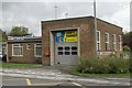
Biddulph fire station
Biddulph fire station, Princess Street, Biddulph, Staffordshire.
Image: © Kevin Hale
Taken: 23 Oct 2006
0.24 miles
6
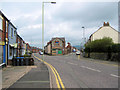
Junction of John Street and High Street
This is the Southern end of both Biddulph High Street and John Street, and where the High Street becomes Tunstall Road. The Northern junction of both the High Street and John Street can be seen at the Image There are also views of John Street here: Image, Image and Image For other views of the High Street see: Image, Image and Image
Image: © Jonathan Kington
Taken: 26 Apr 2010
0.25 miles