IMAGES TAKEN NEAR TO
Stephens Way, STOKE-ON-TRENT, ST7 8PL
Introduction
This page details the photographs taken nearby to Stephens Way, ST7 8PL by members of the Geograph project.
The Geograph project started in 2005 with the aim of publishing, organising and preserving representative images for every square kilometre of Great Britain, Ireland and the Isle of Man.

There are currently over 7.5m images from over14,400 individuals and you can help contribute to the project by visiting https://www.geograph.org.uk
Image Map
Images are licensed for reuse under creativecommons.org/licenses/by-sa/2.0
Notes
- Clicking on the map will re-center to the selected point.
- The higher the marker number, the further away the image location is from the centre of the postcode.
Image Listing (72 Images Found)
Images are licensed for reuse under creativecommons.org/licenses/by-sa/2.0
Image
Details
Distance
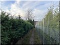
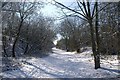
1
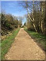
Bignall End: path along former railway trackbed
Image: © Jonathan Hutchins
Taken: 6 Apr 2015
0.06 miles
2
Bignall End: path along former railway trackbed
Image: © Jonathan Hutchins
Taken: 6 Apr 2015
0.08 miles
3
Stepped public footpath
The path leads off the trackbed of the former Audley branch railway.
Image: © Jonathan Hutchins
Taken: 30 Dec 2022
0.09 miles
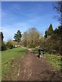
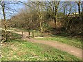
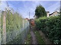
5
Public footpath off Boon Hill Road
Image: © Jonathan Hutchins
Taken: 30 Dec 2022
0.09 miles
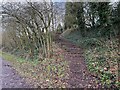
6
Bignall End: path along former railway trackbed
The kink in the pathway and the metal barrier and stile are presumably intended to deter users of wheeled vehicles from using the path as a raceway.
Image: © Jonathan Hutchins
Taken: 6 Apr 2015
0.10 miles
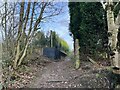
7
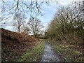
Footpath approaching Bignall End
This is the trackbed of the former Audley branch line.
Image: © Jonathan Hutchins
Taken: 30 Dec 2022
0.11 miles
8
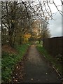
Footpath along former railway trackbed in Bignall End
Looking south. The line was closed to all traffic in 1963 and the track taken up in 1966. Immediately behind the photographer is a steep grassy embankment down to a roundabout. The line was taken over the road by a bridge, on the other side of which was the former Audley Station.
Image: © Jonathan Hutchins
Taken: 16 Nov 2014
0.11 miles
9
Old Railway Line
Looking up the old railway line from Bignall End. The old sidings were just to the right of the photo position now covered with housing.
Image: © Ian Brereton
Taken: Unknown
0.11 miles
10
Public footpath off Boon Hill Road
Image: © Jonathan Hutchins
Taken: 30 Dec 2022
0.12 miles