IMAGES TAKEN NEAR TO
Kite Grove, STOKE-ON-TRENT, ST7 4XW
Introduction
This page details the photographs taken nearby to Kite Grove, ST7 4XW by members of the Geograph project.
The Geograph project started in 2005 with the aim of publishing, organising and preserving representative images for every square kilometre of Great Britain, Ireland and the Isle of Man.

There are currently over 7.5m images from over14,400 individuals and you can help contribute to the project by visiting https://www.geograph.org.uk
Image Map
Images are licensed for reuse under creativecommons.org/licenses/by-sa/2.0
Notes
- Clicking on the map will re-center to the selected point.
- The higher the marker number, the further away the image location is from the centre of the postcode.
Image Listing (3 Images Found)
Images are licensed for reuse under creativecommons.org/licenses/by-sa/2.0
Image
Details
Distance
1
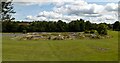
Chinky Park
Skateboard park at Chinky Park in Kidsgrove.
Image: © Peter McDermott
Taken: 13 Jul 2023
0.11 miles
2
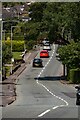
Pennyfields Road
Pennyfields Road in Kidsgrove.
Image: © Peter McDermott
Taken: 13 Jul 2023
0.17 miles
3
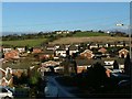
View from Rookery Rd to Trubshaw Edge
This shows the view roughly North East from the top of Rookery Rd to Newchapel Rd, then on across the housing estate and over the fields in the northern part of the grid square to the houses and farm at Trubshaw Edge.
Image: © Steve Lewin
Taken: 3 Jan 2006
0.24 miles