IMAGES TAKEN NEAR TO
Harriseahead Lane, STOKE-ON-TRENT, ST7 4QZ
Introduction
This page details the photographs taken nearby to Harriseahead Lane, ST7 4QZ by members of the Geograph project.
The Geograph project started in 2005 with the aim of publishing, organising and preserving representative images for every square kilometre of Great Britain, Ireland and the Isle of Man.

There are currently over 7.5m images from over14,400 individuals and you can help contribute to the project by visiting https://www.geograph.org.uk
Image Map
Images are licensed for reuse under creativecommons.org/licenses/by-sa/2.0
Notes
- Clicking on the map will re-center to the selected point.
- The higher the marker number, the further away the image location is from the centre of the postcode.
Image Listing (6 Images Found)
Images are licensed for reuse under creativecommons.org/licenses/by-sa/2.0
Image
Details
Distance
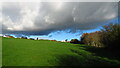
2
Harriseahead Lane
Between Kidsgrove and Mow Cop.
Image: © David Weston
Taken: 4 Jun 2015
0.07 miles
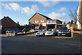
3

What more do you need ?
As so often seems to happen Harriseahead Methodist Chapel is right next door to the local pub, the Nag's Head.
Image: © Steve Lewin
Taken: 8 Sep 2006
0.11 miles
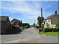
4
High Street, Harriseahead
Between Kidsgrove and Mow Cop.
Image: © David Weston
Taken: 4 Jun 2015
0.11 miles
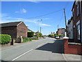
5

Thursfield Community Centre
The local school is to the left of this picture.
Image: © Mick Malpass
Taken: 25 Jun 2012
0.24 miles