IMAGES TAKEN NEAR TO
Church Lane, STOKE-ON-TRENT, ST7 4LS
Introduction
This page details the photographs taken nearby to Church Lane, ST7 4LS by members of the Geograph project.
The Geograph project started in 2005 with the aim of publishing, organising and preserving representative images for every square kilometre of Great Britain, Ireland and the Isle of Man.

There are currently over 7.5m images from over14,400 individuals and you can help contribute to the project by visiting https://www.geograph.org.uk
Image Map
Images are licensed for reuse under creativecommons.org/licenses/by-sa/2.0
Notes
- Clicking on the map will re-center to the selected point.
- The higher the marker number, the further away the image location is from the centre of the postcode.
Image Listing (30 Images Found)
Images are licensed for reuse under creativecommons.org/licenses/by-sa/2.0
Image
Details
Distance
1
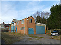
Industrial building, Church Lane, Mow Cop
Brick built with asbestos sheet roof. Its present use is unclear.
Image: © Stephen Craven
Taken: 24 Feb 2019
0.05 miles
2
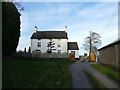
Mow House Farm
The farmhouse is listed grade II (list entry 1374384) as "a well-crafted pre-1840 building with some good architectural details, such as a stone door case, eaves cornice and quoins."
Image: © Stephen Craven
Taken: 24 Feb 2019
0.05 miles
3
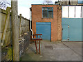
Industrial building, Church Lane, Mow Cop (detail)
The building's present use is unclear but there are two rusty sets of rollers outside one entrance which might give a clue to a former use.
Image: © Stephen Craven
Taken: 24 Feb 2019
0.05 miles
4
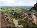
Yet another view!
Looking south west from the rock outcrop at Mow Cop Castle.
Image: © Kate Jewell
Taken: 11 Jun 2008
0.11 miles
5
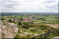
View from Mow Cop Castle
This eighteenth century folly affords fine views across the countryside. This shows the view to the south east across the modern housing in Mow Cop and the ribbon development of Harriseahead Image along Sands Road. Biddulph Image is in the distance to the left.
Image: © Kate Jewell
Taken: 11 Jun 2008
0.12 miles
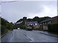
6
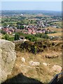
Southeast from Mow Cop
A view from near Mow Cop Castle across the southeastern slopes of the hill. The semi-detached houses are on Moorland Road. The road beyond it is Church Lane, which leads from SJ8657 into SJ8656 between ribbon development and into Harriseahead.
Image: © Derek Harper
Taken: 17 Jul 2006
0.13 miles
7
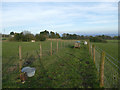
Footpath at Mow House Farm
The path is constrained between fences.
Image: © Stephen Craven
Taken: 24 Feb 2019
0.15 miles
8
Mow Cop Road
The view near Mow Cop, Staffordshire.
Image: © Gordon Griffiths
Taken: 14 Sep 2018
0.17 miles
9
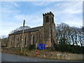
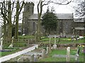
St Thomas church, Mow Cop, tower
The "Commissioners" style church, built 1841-2 by T Stanley, is listed grade II (list entry 1294747).
Image: © Stephen Craven
Taken: 24 Feb 2019
0.17 miles