IMAGES TAKEN NEAR TO
Kidsgrove Bank, STOKE-ON-TRENT, ST7 4HB
Introduction
This page details the photographs taken nearby to Kidsgrove Bank, ST7 4HB by members of the Geograph project.
The Geograph project started in 2005 with the aim of publishing, organising and preserving representative images for every square kilometre of Great Britain, Ireland and the Isle of Man.

There are currently over 7.5m images from over14,400 individuals and you can help contribute to the project by visiting https://www.geograph.org.uk
Image Map
Images are licensed for reuse under creativecommons.org/licenses/by-sa/2.0
Notes
- Clicking on the map will re-center to the selected point.
- The higher the marker number, the further away the image location is from the centre of the postcode.
Image Listing (5 Images Found)
Images are licensed for reuse under creativecommons.org/licenses/by-sa/2.0
Image
Details
Distance
2
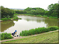
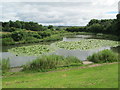
By a Sleepy Lagoon
Not quite a tropical island but a fishing pond at Goldenhill Golf Course, Stoke on Trent.
Image: © Phil Eptlett
Taken: 22 Jun 2006
0.16 miles
3
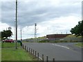
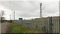
Reservoir and mobile phone masts
This covered reservoir is on the north side of Gill Bank road at the junction with Chatterley Drive. Behind it are 3 mobile phone masts and base stations grouped together in one field.
Image: © Steve Lewin
Taken: 7 Jul 2006
0.22 miles
4
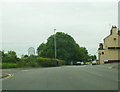
Lake at Goldenhill
On the northern edge of Goldenhill, near Mobberley Road.
Image: © David Weston
Taken: 5 Jul 2016
0.22 miles