IMAGES TAKEN NEAR TO
Galleys Bank, STOKE-ON-TRENT, ST7 4DE
Introduction
This page details the photographs taken nearby to Galleys Bank, ST7 4DE by members of the Geograph project.
The Geograph project started in 2005 with the aim of publishing, organising and preserving representative images for every square kilometre of Great Britain, Ireland and the Isle of Man.

There are currently over 7.5m images from over14,400 individuals and you can help contribute to the project by visiting https://www.geograph.org.uk
Image Map
Images are licensed for reuse under creativecommons.org/licenses/by-sa/2.0
Notes
- Clicking on the map will re-center to the selected point.
- The higher the marker number, the further away the image location is from the centre of the postcode.
Image Listing (6 Images Found)
Images are licensed for reuse under creativecommons.org/licenses/by-sa/2.0
Image
Details
Distance
4
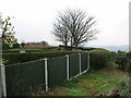
End of the gardens
There was once a triangulation pillar here. Beyond these gardens and the path the ground falls away sharply.
Image: © Richard Webb
Taken: 1 Apr 2004
0.16 miles
5
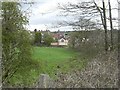
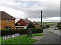
Newchapel Rd to Rookery
View from Newchapel Road across to the rear of St Saviour's Church Rookery
Image: © Steve Lewin
Taken: 25 Apr 2006
0.25 miles
6
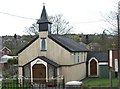
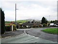
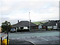
St Saviour's Church Rookery
St Saviour's is built almost entirely of corrugated iron, not the most conventional material for church building.
Image: © Steve Lewin
Taken: 25 Apr 2006
0.25 miles