
IMAGES TAKEN NEAR TO
Hardings Row, STOKE-ON-TRENT, ST7 3NE
Introduction
This page details the photographs taken nearby to Hardings Row, ST7 3NE by members of the Geograph project.
The Geograph project started in 2005 with the aim of publishing, organising and preserving representative images for every square kilometre of Great Britain, Ireland and the Isle of Man.

There are currently over 7.5m images from over14,400 individuals and you can help contribute to the project by visiting https://www.geograph.org.uk
Image Map
Images are licensed for reuse under creativecommons.org/licenses/by-sa/2.0
Notes
- Clicking on the map will re-center to the selected point.
- The higher the marker number, the further away the image location is from the centre of the postcode.
Image Listing (93 Images Found)
Images are licensed for reuse under creativecommons.org/licenses/by-sa/2.0
Image
Details
Distance
1
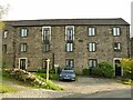
The former Coronation Mill, Mow Cop
Built in 1902 (hence named after the coronation of Edward VII on 9 August 1902), this was a fustian mill that was in use until at least 1923 (source: mowcop.info). It has now been converted into apartments.
Image: © Stephen Craven
Taken: 16 Oct 2021
0.02 miles
2
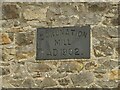
Datestone on the former Coronation Mill
See Image for context and history.
Image: © Stephen Craven
Taken: 16 Oct 2021
0.02 miles
3
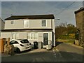
The Old Post Office, Mow Cop
The house looks quite modern so may be on the site of, rather than the actual, post office building.
Image: © Stephen Craven
Taken: 16 Oct 2021
0.04 miles
4
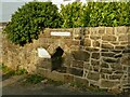
Parson's Well, Mow Cop
There are several wells shown in the village on this map, probably indicating a change of geology favourable to natural springs. This own was opened in 1858 and due to its more ornate construction is listed grade II (list entry 1309822). See also Image
Image: © Stephen Craven
Taken: 16 Oct 2021
0.04 miles
5
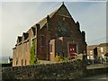
Primitive Methodist Chapel, Woodcock Lane, Mow Cop
Primitive Methodism started in this village in 1807 and the (now United) Methodist church is still open. The date on the building is 1860; another contributor gives a date of 1857 Image but that may have been the start of construction, and 1860 when it was finished and dedicated.
Image: © Stephen Craven
Taken: 16 Oct 2021
0.05 miles
6
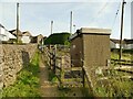
Gas installation below Woodcock Lane
Image: © Stephen Craven
Taken: 16 Oct 2021
0.06 miles
7
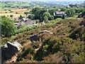
Slopes of Mow Cop
Looking down the rocky heathery slopes from part way up to Mow Cop Castle. The houses shown in Image are below left. The large square building to the right, which straddles the gridline with SX8556, is a Wesleyan chapel built in 1852, now a museum.
Image: © Derek Harper
Taken: 17 Jul 2006
0.06 miles
8

Parson's Well, Mow Cop
Dated 1858, a similar time to the nearby Primitive Methodist Memorial Chapel and was apparently funded by Miss Wilbraham. An ode to this fact was written by Mr David Oakes (taken with thanks from http://www.mowcop.info/htm/wells.htm#parsons)
"Mrs Wilbraham is a Lady born
All other women she doth excel
Twenty guineas she did lay down
For making Parsons Well."
Image: © Sue Adair
Taken: 25 Aug 2008
0.06 miles
9
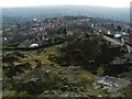
Mow Cop Quarry and Village
Looking over the stone quarry towards the village of Mow Cop, taken from near the 18th Century Folly. A museum at SJ856570 is open daily May-Sept (not much use in Feb!). More information about Mow Cop can be found at http://www.mowcop.com .
Image: © Iain McDonald
Taken: 18 Feb 2006
0.07 miles
10

Wesleyan Memorial Church, Mow Cop
A brief history and interesting theory on its construction can be found at: http://www.mowcop.info/htm/wesleyan.htm
Image: © Sue Adair
Taken: 25 Aug 2008
0.07 miles