IMAGES TAKEN NEAR TO
Sycamore Avenue, STOKE-ON-TRENT, ST7 2RF
Introduction
This page details the photographs taken nearby to Sycamore Avenue, ST7 2RF by members of the Geograph project.
The Geograph project started in 2005 with the aim of publishing, organising and preserving representative images for every square kilometre of Great Britain, Ireland and the Isle of Man.

There are currently over 7.5m images from over14,400 individuals and you can help contribute to the project by visiting https://www.geograph.org.uk
Image Map
Images are licensed for reuse under creativecommons.org/licenses/by-sa/2.0
Notes
- Clicking on the map will re-center to the selected point.
- The higher the marker number, the further away the image location is from the centre of the postcode.
Image Listing (42 Images Found)
Images are licensed for reuse under creativecommons.org/licenses/by-sa/2.0
Image
Details
Distance
2
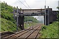
Bridge, Alsager railway station
The bridge at the eastern end of the platforms.
Image: © El Pollock
Taken: 13 Jun 2015
0.18 miles
4
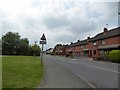
Junction of Birch Avenue and Yew Tree Close, Alsager
Image: © Jonathan Hutchins
Taken: 6 Jul 2017
0.18 miles
5
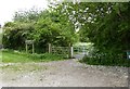
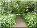
Alsager: start of the Merelake Way
A small car park on Talke Road gives access to the Merelake Way.
Image: © Jonathan Hutchins
Taken: 28 May 2016
0.18 miles
6
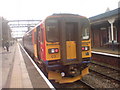
Alsager Railway Station
Alsager railway station between Crewe and Stoke On Trent
Image: © John Dyson
Taken: 10 Nov 2009
0.18 miles
7
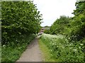
Merelake Way looking back to Talke Road
Image: © Jonathan Hutchins
Taken: 28 May 2016
0.19 miles
8
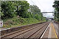
Disused platform, Alsager railway station
The disused eastern section of the Kidsgrove-bound platform.
Image: © El Pollock
Taken: 13 Jun 2015
0.20 miles
9
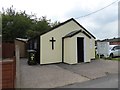
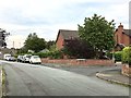
Alsager: Linley Adventist Mission
Image: © Jonathan Hutchins
Taken: 28 May 2016
0.20 miles
10
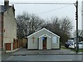
Alsager Seventh Day Adventist Church
The small chapel is not shown on pre-WWII maps but is shown as a 'hall' on post-war maps. The 'Seventh Day' in the church's name indicates that they worship on the Jewish Shabbat rather than on Sunday, and indeed a prayer meeting was in progress on this Saturday afternoon.
Image: © Stephen Craven
Taken: 28 Dec 2024
0.20 miles