IMAGES TAKEN NEAR TO
West Avenue, STOKE-ON-TRENT, ST7 1TU
Introduction
This page details the photographs taken nearby to West Avenue, ST7 1TU by members of the Geograph project.
The Geograph project started in 2005 with the aim of publishing, organising and preserving representative images for every square kilometre of Great Britain, Ireland and the Isle of Man.

There are currently over 7.5m images from over14,400 individuals and you can help contribute to the project by visiting https://www.geograph.org.uk
Image Map
Images are licensed for reuse under creativecommons.org/licenses/by-sa/2.0
Notes
- Clicking on the map will re-center to the selected point.
- The higher the marker number, the further away the image location is from the centre of the postcode.
Image Listing (15 Images Found)
Images are licensed for reuse under creativecommons.org/licenses/by-sa/2.0
Image
Details
Distance
1
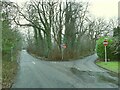
Triangular junction on Coppice Road
Approaching the A5011, there are separate entry and exit lanes, an arrangement that appears from old maps to date back a long time (though the one-way signage is probably more recent).
Image: © Stephen Craven
Taken: 28 Dec 2024
0.14 miles
5
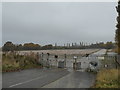
Talke: development land on Linley Road
Formerly site of the Linley Trading Estate, an approximately 8.79 acre site with outline planning permission for 139 dwellings.
Image: © Jonathan Hutchins
Taken: 30 Oct 2016
0.15 miles
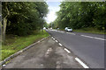
6
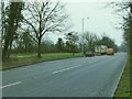
Layby on Linley Lane
To the left of the layby is a remnant of a previous alignment of the road.
Image: © Stephen Craven
Taken: 28 Dec 2024
0.16 miles
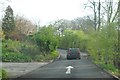
9
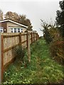
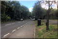
Talke: public footpath off Walton Way
Image: © Jonathan Hutchins
Taken: 30 Oct 2016
0.18 miles
10
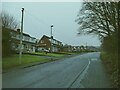
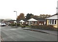
Houses on Coppice Road
Old maps show an 'entrenchment' (linear earthwork) parallel to the road, roughly where these houses are.
Image: © Stephen Craven
Taken: 28 Dec 2024
0.18 miles