IMAGES TAKEN NEAR TO
Clough Hall Road, STOKE-ON-TRENT, ST7 1AX
Introduction
This page details the photographs taken nearby to Clough Hall Road, ST7 1AX by members of the Geograph project.
The Geograph project started in 2005 with the aim of publishing, organising and preserving representative images for every square kilometre of Great Britain, Ireland and the Isle of Man.

There are currently over 7.5m images from over14,400 individuals and you can help contribute to the project by visiting https://www.geograph.org.uk
Image Map
Images are licensed for reuse under creativecommons.org/licenses/by-sa/2.0
Notes
- Clicking on the map will re-center to the selected point.
- The higher the marker number, the further away the image location is from the centre of the postcode.
Image Listing (15 Images Found)
Images are licensed for reuse under creativecommons.org/licenses/by-sa/2.0
Image
Details
Distance
1
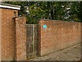
'Access to drying area', Westmorland Avenue, Kidsgrove
The sign is for a communal clothes drying area Image
Image: © Stephen Craven
Taken: 27 Oct 2024
0.13 miles
2
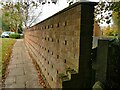
Brick wall, Westmorland Avenue, Kidsgrove
An unusual brick-bonding pattern: essentially all stretchers, but every fourth course has occasional header bricks protruding from the wall. Does it have a recognised name?
Image: © Stephen Craven
Taken: 27 Oct 2024
0.13 miles
3
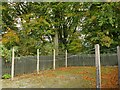
Drying area, Westmorland Avenue, Kidsgrove
A communal clothes drying area in a mid-20th century housing estate. With the advent of tumble dryers and the near-death of neighbourly sharing, I cannot imagine this facility being provided in any contemporary development. Corrosion of the shallow-cover reinforcement in the concrete posts suggests it may not last much longer anyway.
Image: © Stephen Craven
Taken: 27 Oct 2024
0.14 miles
4
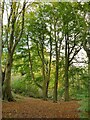
Tall trees in Bathpool Wood
The woodland is shown on maps from 1899 or earlier, so these (beech?) trees have had plenty of time to mature.
Image: © Stephen Craven
Taken: 27 Oct 2024
0.16 miles
5
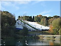
Kidsgrove Ski Centre dry ski slopes
Image: © Jonathan Hutchins
Taken: 22 Oct 2016
0.17 miles
6
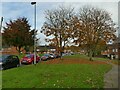
Clough Hall Road, Kidsgrove
A residential estate, probably of the mid 20th century, with generous verges between roads and housing.
Image: © Stephen Craven
Taken: 27 Oct 2024
0.19 miles
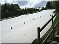
8
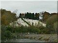
Kidsgrove dry ski slope
See Image for a closer view. The slope is only about 90 metres long with a drop of around 20 metres, and is taken out of Bathpool Wood.
Image: © Stephen Craven
Taken: 27 Oct 2024
0.19 miles
9

I can see (two) rainbows
Yet another of the recent heavy rain/hail storms in North Staffordshire coincided with the setting sun to create two rainbows over our neighbour's garden shed (bottom left). In the brighter of the two, even the violet inner arc is clearly seen... a spectacular accompaniment to our evening meal!
Image: © Hazel Hambidge
Taken: 18 Jun 2011
0.20 miles