IMAGES TAKEN NEAR TO
Kinnersley Avenue, STOKE-ON-TRENT, ST7 1AP
Introduction
This page details the photographs taken nearby to Kinnersley Avenue, ST7 1AP by members of the Geograph project.
The Geograph project started in 2005 with the aim of publishing, organising and preserving representative images for every square kilometre of Great Britain, Ireland and the Isle of Man.

There are currently over 7.5m images from over14,400 individuals and you can help contribute to the project by visiting https://www.geograph.org.uk
Image Map
Images are licensed for reuse under creativecommons.org/licenses/by-sa/2.0
Notes
- Clicking on the map will re-center to the selected point.
- The higher the marker number, the further away the image location is from the centre of the postcode.
Image Listing (15 Images Found)
Images are licensed for reuse under creativecommons.org/licenses/by-sa/2.0
Image
Details
Distance
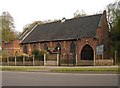
1
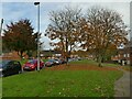
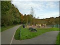
Clough Hall Road, Kidsgrove
A residential estate, probably of the mid 20th century, with generous verges between roads and housing.
Image: © Stephen Craven
Taken: 27 Oct 2024
0.09 miles
3
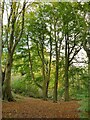
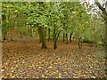
Tall trees in Bathpool Wood
The woodland is shown on maps from 1899 or earlier, so these (beech?) trees have had plenty of time to mature.
Image: © Stephen Craven
Taken: 27 Oct 2024
0.15 miles
4
'Access to drying area', Westmorland Avenue, Kidsgrove
The sign is for a communal clothes drying area Image
Image: © Stephen Craven
Taken: 27 Oct 2024
0.15 miles
5
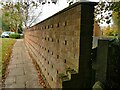
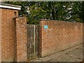
Brick wall, Westmorland Avenue, Kidsgrove
An unusual brick-bonding pattern: essentially all stretchers, but every fourth course has occasional header bricks protruding from the wall. Does it have a recognised name?
Image: © Stephen Craven
Taken: 27 Oct 2024
0.16 miles
6
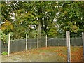
Drying area, Westmorland Avenue, Kidsgrove
A communal clothes drying area in a mid-20th century housing estate. With the advent of tumble dryers and the near-death of neighbourly sharing, I cannot imagine this facility being provided in any contemporary development. Corrosion of the shallow-cover reinforcement in the concrete posts suggests it may not last much longer anyway.
Image: © Stephen Craven
Taken: 27 Oct 2024
0.16 miles
7
Footpath through Bathpool Wood
The path is not very clear on the ground, especially in autumn with leaf fall well under way. However, it is marked on Open Street Map and also on the 1899 OS map which oddly shows a footbridge crossing it about here. That map shows the path linking two (already closed) small collieries, and the 1879 map shows it to have been the route of an earlier tramway.
Image: © Stephen Craven
Taken: 27 Oct 2024
0.18 miles
10
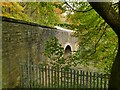
Southern portal of Harecastle 'new' railway tunnel
As explained by another contributor Image this tunnel is on a diversionary route opened in 1965. The ground under this part of Kidsgrove is a warren of human excavations, with one current and three abandoned railway tunnels, a pair of canal tunnels, and several disused mine shafts, presumably with associated levels.
Image: © Stephen Craven
Taken: 27 Oct 2024
0.22 miles