IMAGES TAKEN NEAR TO
Silverstone Crescent, STOKE-ON-TRENT, ST6 6XP
Introduction
This page details the photographs taken nearby to Silverstone Crescent, ST6 6XP by members of the Geograph project.
The Geograph project started in 2005 with the aim of publishing, organising and preserving representative images for every square kilometre of Great Britain, Ireland and the Isle of Man.

There are currently over 7.5m images from over14,400 individuals and you can help contribute to the project by visiting https://www.geograph.org.uk
Image Map
Images are licensed for reuse under creativecommons.org/licenses/by-sa/2.0
Notes
- Clicking on the map will re-center to the selected point.
- The higher the marker number, the further away the image location is from the centre of the postcode.
Image Listing (5 Images Found)
Images are licensed for reuse under creativecommons.org/licenses/by-sa/2.0
Image
Details
Distance
1
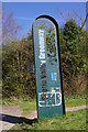
Scotia Valley Greenway
This somewhat vandalised sign tells us that the former route of the Potteries Loop railway line is now the Scotia Valley Greenway - also part of Sustrans route 5.
Image: © Stephen McKay
Taken: 24 Mar 2017
0.20 miles
2
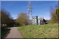
Scotia Valley Greenway
The green sign in front of the electricity substation identifies this as the Scotia Valley Greenway although the name does not seem to be generally well promoted. It is in fact part of the former Potteries Loop railway that ran from Etruria to Kidsgrove; passenger services were withdrawn in 1964 although some sections continued to see freight trains until the mid-1970s.
Image: © Stephen McKay
Taken: 24 Mar 2017
0.20 miles
3
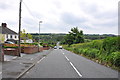
Road on the edge of Turnhurst
Goldenhill Church and Goldenhill Golf Club can be seen in the distance.
Image: © Mick Malpass
Taken: 25 Jun 2012
0.20 miles
4
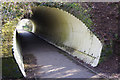
Tunnel under Colclough Lane
A closer view of the tunnel seen in this image: Image
Image: © Stephen McKay
Taken: 24 Mar 2017
0.22 miles
5
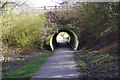
Tunnel under Colclough Lane
This tunnel allows walkers and cyclists on the Scotia Valley Greenway, the former Potteries Loop railway, to remain on the level although it is obviously not the original structure. On the other side is the site of Newchapel & Goldenhill station, closed in 1964; this stretch of the railway was closed to freight two years later.
Image: © Stephen McKay
Taken: 24 Mar 2017
0.23 miles