IMAGES TAKEN NEAR TO
Warreners Walk, STOKE-ON-TRENT, ST6 5SF
Introduction
This page details the photographs taken nearby to Warreners Walk, ST6 5SF by members of the Geograph project.
The Geograph project started in 2005 with the aim of publishing, organising and preserving representative images for every square kilometre of Great Britain, Ireland and the Isle of Man.

There are currently over 7.5m images from over14,400 individuals and you can help contribute to the project by visiting https://www.geograph.org.uk
Image Map
Images are licensed for reuse under creativecommons.org/licenses/by-sa/2.0
Notes
- Clicking on the map will re-center to the selected point.
- The higher the marker number, the further away the image location is from the centre of the postcode.
Image Listing (23 Images Found)
Images are licensed for reuse under creativecommons.org/licenses/by-sa/2.0
Image
Details
Distance
1
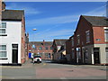
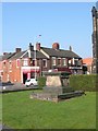
Greengates Street, Tunstall
Looking along Greengates Street towards business premises on Furlong Road. In the foreground is Meir Street.
Image: © David Weston
Taken: 4 Jun 2015
0.16 miles
5
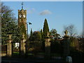
Tunstall Park
Tunstall park is one of the many small Victorian parks which thrive in much of country and particularly in the Midlands. The clock tower and park gates are relatively recent additions added in the early 1900s.
Image: © Steve Lewin
Taken: 27 Dec 2005
0.19 miles
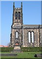
6
Churchyard at Christ Church Tunstall
Image: © Clive Woolliscroft
Taken: 26 Mar 2007
0.20 miles
7
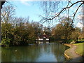
Tunstall Park Lake
The old boat house in the background is no longer used but until relatively recently rowing boats were available for hire. The boathouse and indeed the whole park are Grade II listed.
Image: © Steve Lewin
Taken: 27 Dec 2005
0.20 miles
8
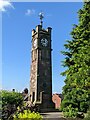
The Adams Clock Tower, Tunstall Park, Stoke-on-Trent
Image: © Andrew Woodvine
Taken: 20 Jun 2022
0.20 miles
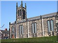
9
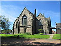
Christ Church, Tunstall
Viewed from the north-east.
Image: © David Weston
Taken: 4 Jun 2015
0.21 miles
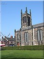
10
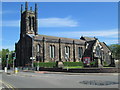
Christ Church, Tunstall
The church was built in 1832. Seen from the south-west, at the junction of the main road north of Tunstall (the A50) with Furlong Road. The dark patch on the road at the bottom right of the photo is a mini-roundabout.
Image: © David Weston
Taken: 4 Jun 2015
0.21 miles