IMAGES TAKEN NEAR TO
St. Aidans Street, STOKE-ON-TRENT, ST6 5HQ
Introduction
This page details the photographs taken nearby to St. Aidans Street, ST6 5HQ by members of the Geograph project.
The Geograph project started in 2005 with the aim of publishing, organising and preserving representative images for every square kilometre of Great Britain, Ireland and the Isle of Man.

There are currently over 7.5m images from over14,400 individuals and you can help contribute to the project by visiting https://www.geograph.org.uk
Image Map
Images are licensed for reuse under creativecommons.org/licenses/by-sa/2.0
Notes
- Clicking on the map will re-center to the selected point.
- The higher the marker number, the further away the image location is from the centre of the postcode.
Image Listing (10 Images Found)
Images are licensed for reuse under creativecommons.org/licenses/by-sa/2.0
Image
Details
Distance
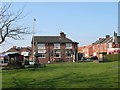
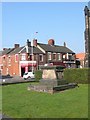
2
Christ Church, Tunstall
https://www.gandtparish.co.uk/
Image: © Brian Deegan
Taken: 27 Oct 2019
0.16 miles
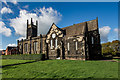
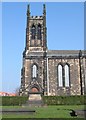
3
Christ Church, Tunstall
The church was built in 1832. Seen from the south-west, at the junction of the main road north of Tunstall (the A50) with Furlong Road. The dark patch on the road at the bottom right of the photo is a mini-roundabout.
Image: © David Weston
Taken: 4 Jun 2015
0.17 miles
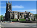
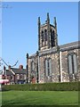
4
Christ Church, Tunstall
Viewed from the north-east.
Image: © David Weston
Taken: 4 Jun 2015
0.17 miles
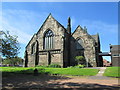
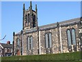
5
Churchyard at Christ Church Tunstall
Image: © Clive Woolliscroft
Taken: 26 Mar 2007
0.18 miles
9
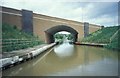
The Trent & Mersey Canal just south of Harecastle Tunnel
looking north through the A527 bridge
Image: © Andrew Longton
Taken: 9 Jun 1998
0.20 miles
10
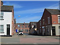
Greengates Street, Tunstall
Looking along Greengates Street towards business premises on Furlong Road. In the foreground is Meir Street.
Image: © David Weston
Taken: 4 Jun 2015
0.22 miles