IMAGES TAKEN NEAR TO
Wyreley Way, STOKE-ON-TRENT, ST6 5GH
Introduction
This page details the photographs taken nearby to Wyreley Way, ST6 5GH by members of the Geograph project.
The Geograph project started in 2005 with the aim of publishing, organising and preserving representative images for every square kilometre of Great Britain, Ireland and the Isle of Man.

There are currently over 7.5m images from over14,400 individuals and you can help contribute to the project by visiting https://www.geograph.org.uk
Image Map
Images are licensed for reuse under creativecommons.org/licenses/by-sa/2.0
Notes
- Clicking on the map will re-center to the selected point.
- The higher the marker number, the further away the image location is from the centre of the postcode.
Image Listing (7 Images Found)
Images are licensed for reuse under creativecommons.org/licenses/by-sa/2.0
Image
Details
Distance
1

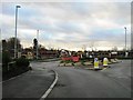
Old Marl Hole, Sandyford
You'll find this marked on the map as Clay Pit (dis) but in this area all such disused diggings are called Marl Holes, marl being a specific type of clay once used in the pottery industry.
Image: © Steve Lewin
Taken: 4 Jul 2006
0.08 miles

5
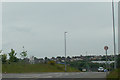
Capricorn Way, Chell
Seen from its junction with Zodiac Drive, this is one of a cluster of streets with astrology-themed names.
Image: © Stephen McKay
Taken: 24 Mar 2017
0.21 miles
6
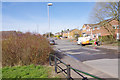
Zodiac Drive, Chell
A man from Kelly Communications is attending to the wiring on behalf of Virgin Media on this suburban street.
Image: © Stephen McKay
Taken: 24 Mar 2017
0.22 miles
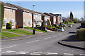
7
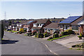
Zodiac Drive, Chell
An interesting mix of house designs on the north side of Zodiac Drive.
Image: © Stephen McKay
Taken: 24 Mar 2017
0.22 miles