IMAGES TAKEN NEAR TO
Belvide Grove, STOKE-ON-TRENT, ST6 5GD
Introduction
This page details the photographs taken nearby to Belvide Grove, ST6 5GD by members of the Geograph project.
The Geograph project started in 2005 with the aim of publishing, organising and preserving representative images for every square kilometre of Great Britain, Ireland and the Isle of Man.

There are currently over 7.5m images from over14,400 individuals and you can help contribute to the project by visiting https://www.geograph.org.uk
Image Map
Images are licensed for reuse under creativecommons.org/licenses/by-sa/2.0
Notes
- Clicking on the map will re-center to the selected point.
- The higher the marker number, the further away the image location is from the centre of the postcode.
Image Listing (6 Images Found)
Images are licensed for reuse under creativecommons.org/licenses/by-sa/2.0
Image
Details
Distance
1
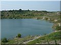
Old Marl Hole, Sandyford
You'll find this marked on the map as Clay Pit (dis) but in this area all such disused diggings are called Marl Holes, marl being a specific type of clay once used in the pottery industry.
Image: © Steve Lewin
Taken: 4 Jul 2006
0.07 miles

5

Sandyford cricket ground
Viewed from the end of Shelford Road.
Image: © David Weston
Taken: 5 Jul 2016
0.18 miles