IMAGES TAKEN NEAR TO
Dunning Street, STOKE-ON-TRENT, ST6 5AP
Introduction
This page details the photographs taken nearby to Dunning Street, ST6 5AP by members of the Geograph project.
The Geograph project started in 2005 with the aim of publishing, organising and preserving representative images for every square kilometre of Great Britain, Ireland and the Isle of Man.

There are currently over 7.5m images from over14,400 individuals and you can help contribute to the project by visiting https://www.geograph.org.uk
Image Map
Images are licensed for reuse under creativecommons.org/licenses/by-sa/2.0
Notes
- Clicking on the map will re-center to the selected point.
- The higher the marker number, the further away the image location is from the centre of the postcode.
Image Listing (45 Images Found)
Images are licensed for reuse under creativecommons.org/licenses/by-sa/2.0
Image
Details
Distance
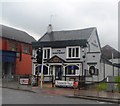
2
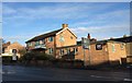
Tunstall - The Wheatsheaf
On High Street.
Image: © Dave Bevis
Taken: 7 Jul 2011
0.06 miles
3
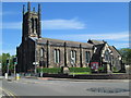
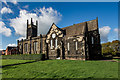
Christ Church, Tunstall
The church was built in 1832. Seen from the south-west, at the junction of the main road north of Tunstall (the A50) with Furlong Road. The dark patch on the road at the bottom right of the photo is a mini-roundabout.
Image: © David Weston
Taken: 4 Jun 2015
0.12 miles
4
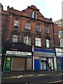
Tunstall: closed shops on High Street
Some would ascribe the decline in traditional 'High Street' shops to the rise of less central retail parks - such as, in the case of Tunstall, Jasper Square and Alexandra Park.
Image: © Jonathan Hutchins
Taken: 30 Dec 2014
0.12 miles
5
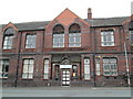
Victorian building in Forster Street, Tunstall
The front of an impressive building from the Victorian era; over the main entrance is the name "Wolstanton School Board"; also the date of the building, A.D. 1880. A much more recent sign over the main entrance reads "Tunstall SureStart Centre": it is a children's centre for under-5s.
Image: © David Weston
Taken: 25 Aug 2013
0.13 miles
6
Christ Church, Tunstall
https://www.gandtparish.co.uk/
Image: © Brian Deegan
Taken: 27 Oct 2019
0.13 miles
7
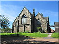
Christ Church, Tunstall
Viewed from the north-east.
Image: © David Weston
Taken: 4 Jun 2015
0.13 miles
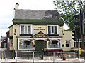
9
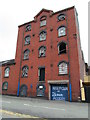
Tall building in Oldcourt Street, Tunstall
This building is adjacent to the Coach and Horses pub (which is to the right). The upper storeys seem to be unused, but the ground floor is part of DefyGravity Dance Studios, the entrance of which is in Roundwell Street (round the corner on the left).
Image: © David Weston
Taken: 25 Aug 2013
0.13 miles
10
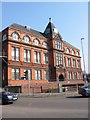
Queen Victoria Jubilee Buildings
Image: © Clive Woolliscroft
Taken: 26 Mar 2007
0.14 miles