IMAGES TAKEN NEAR TO
Odell Grove, STOKE-ON-TRENT, ST6 4JY
Introduction
This page details the photographs taken nearby to Odell Grove, ST6 4JY by members of the Geograph project.
The Geograph project started in 2005 with the aim of publishing, organising and preserving representative images for every square kilometre of Great Britain, Ireland and the Isle of Man.

There are currently over 7.5m images from over14,400 individuals and you can help contribute to the project by visiting https://www.geograph.org.uk
Image Map
Images are licensed for reuse under creativecommons.org/licenses/by-sa/2.0
Notes
- Clicking on the map will re-center to the selected point.
- The higher the marker number, the further away the image location is from the centre of the postcode.
Image Listing (4 Images Found)
Images are licensed for reuse under creativecommons.org/licenses/by-sa/2.0
Image
Details
Distance
1
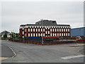
Federation Road, Burslem
On the left in the distance is the junction of Federation Road with Westport Road. The large office building is the Operations Centre of UCB (United Christian Broadcasters).
Image: © David Weston
Taken: 25 Aug 2013
0.13 miles
2
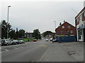
Scotia Road, Burslem
Between Tunstall and Burslem, looking south-east. The junction with Chatterley Street is near the blue fence on the right.
Image: © David Weston
Taken: 25 Aug 2013
0.22 miles
3
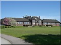
Brownhills High School
Opened in the early 1930s as the first grammar school for girls in Stoke-on-Trent the school is currently officially known as Brownhills Maths and Computing College but everyone, including students and teachers, still call it Brownhills High.
Image: © Steve Lewin
Taken: 5 May 2006
0.25 miles
4
Scotia Road, Burslem
Between Tunstall and Burslem. Looking south-east from the junction with Federation Road.
Image: © David Weston
Taken: 25 Aug 2013
0.25 miles