IMAGES TAKEN NEAR TO
Federation Road, STOKE-ON-TRENT, ST6 4HX
Introduction
This page details the photographs taken nearby to Federation Road, ST6 4HX by members of the Geograph project.
The Geograph project started in 2005 with the aim of publishing, organising and preserving representative images for every square kilometre of Great Britain, Ireland and the Isle of Man.

There are currently over 7.5m images from over14,400 individuals and you can help contribute to the project by visiting https://www.geograph.org.uk
Image Map
Images are licensed for reuse under creativecommons.org/licenses/by-sa/2.0
Notes
- Clicking on the map will re-center to the selected point.
- The higher the marker number, the further away the image location is from the centre of the postcode.
Image Listing (23 Images Found)
Images are licensed for reuse under creativecommons.org/licenses/by-sa/2.0
Image
Details
Distance
1
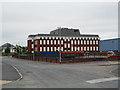
Federation Road, Burslem
On the left in the distance is the junction of Federation Road with Westport Road. The large office building is the Operations Centre of UCB (United Christian Broadcasters).
Image: © David Weston
Taken: 25 Aug 2013
0.10 miles
2
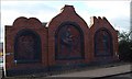
Traditional Industries, panel at Burslem
Location: Woodbank Street, Burslem (at the roadside)
Installed: 1992
Commissioned by: Staffordshire County Council
Sculptor: John McKenna
Each of the three reliefs is situated within a black edged arch,
with the head of the arch being shaped to reflect the image within the arch.
These sculptures celebrate three traditional industries of Burslem, brick manufacture, mining and pottery.
The relief of the coal miner is within a frame that has the shape of a pithead's two wheels. He kneels on one knee and uses a pickaxe to chip at the coal face that surrounds him.
The second and largest relief shows a potter working on a potter's wheel. It is set within a frame in the shape of a pottery kiln. The bowls he is manufacturing are hardening on a shelf in the foreground of the image.
The last relief is set within a frame in the shape of a brick kiln. It shows a brickmaker removing a brick from its mould with two shelves of bricks hardening in the background.
Image: © Steven Birks
Taken: Unknown
0.12 miles
3
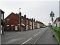
Scotia Road, Burslem
Between Tunstall and Burslem. Looking south-east from the junction with Federation Road.
Image: © David Weston
Taken: 25 Aug 2013
0.13 miles
5
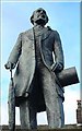
Sir Henry Doulton (1820-1897) at Burslem
Location: Market Place, Burslem
Date of design: 1986
Installed: 11 June 1991
Commissioned by: Burslem Urban District Council
Sculpture: Colin Melbourne
Statue is near to the old Burslem Town Hall:- http://www.geograph.org.uk/photo/272797
(On rear of pedestal, on plaque):
This statue was unveiled
by Mr. Stuart Lyon
Chairman, Royal Doulton Limited
11th June 1991
Sir Henry Doulton was the first potter to receive the
Albert Medal and to be knighted for his services
to the ceramic industry. The great potter of his age, he
acquired the Nile Street factory in Burslem in 1877 and
gave the company that bears his name the foundations
of international success.
Image: © Steven Birks
Taken: Unknown
0.16 miles
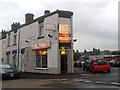
6
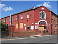
Burslem - Wade Heath Pottery Works
On Westport Road.
Image: © Dave Bevis
Taken: 2 May 2011
0.16 miles
7
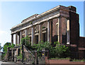
Burslem - Sunday School
This is all that remains of Burslem's Hill Top Methodist Sunday School. The rest was demolished in 1987, following a fire in 1983.
Image: © Dave Bevis
Taken: 2 May 2011
0.19 miles
8
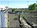
Allotment Gardens, Burslem
Allotment gardens were originally provided to give people living in densely packed terraced houses somewhere to grow their own food. There are not many left now.
Image: © Steve Lewin
Taken: 5 May 2006
0.20 miles
9
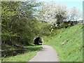
Greenway at Burslem
Stoke-on-Trent had many miles of railways connecting coal mines, steel works and potteries. Many of them have now been converted to pleasant walks, usually called Greenways. This one goes from Burslem to Tunstall and on to Kidsgrove.
Image: © Steve Lewin
Taken: 5 May 2006
0.21 miles
10
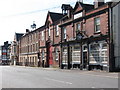
Burslem - Westport Street
These are the buildings on the south-west side Of Westport Street, close to Burslem town centre.
Image: © Dave Bevis
Taken: 2 May 2011
0.21 miles