IMAGES TAKEN NEAR TO
Gallimore Close, STOKE-ON-TRENT, ST6 4DZ
Introduction
This page details the photographs taken nearby to Gallimore Close, ST6 4DZ by members of the Geograph project.
The Geograph project started in 2005 with the aim of publishing, organising and preserving representative images for every square kilometre of Great Britain, Ireland and the Isle of Man.

There are currently over 7.5m images from over14,400 individuals and you can help contribute to the project by visiting https://www.geograph.org.uk
Image Map
Images are licensed for reuse under creativecommons.org/licenses/by-sa/2.0
Notes
- Clicking on the map will re-center to the selected point.
- The higher the marker number, the further away the image location is from the centre of the postcode.
Image Listing (4 Images Found)
Images are licensed for reuse under creativecommons.org/licenses/by-sa/2.0
Image
Details
Distance
1
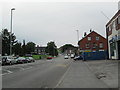
Scotia Road, Burslem
Between Tunstall and Burslem, looking south-east. The junction with Chatterley Street is near the blue fence on the right.
Image: © David Weston
Taken: 25 Aug 2013
0.15 miles
2
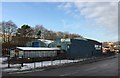
Tunstall: Morris Brothers, Scotia Road
Morris Brothers was formed in 1948 by two brothers, Fred and Harry Morris. It began by offering specialised engineering services to the local pottery industry, but early on became involved with the precast concrete industry, and now works largely in this area. It is still a family firm. http://www.morrisbrothers.com/about-us.php
Image: © Jonathan Hutchins
Taken: 30 Dec 2014
0.19 miles
3
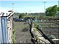
Allotment Gardens, Burslem
Allotment gardens were originally provided to give people living in densely packed terraced houses somewhere to grow their own food. There are not many left now.
Image: © Steve Lewin
Taken: 5 May 2006
0.24 miles
4
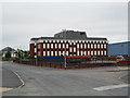
Federation Road, Burslem
On the left in the distance is the junction of Federation Road with Westport Road. The large office building is the Operations Centre of UCB (United Christian Broadcasters).
Image: © David Weston
Taken: 25 Aug 2013
0.24 miles