IMAGES TAKEN NEAR TO
Emerson Road, STOKE-ON-TRENT, ST6 3JJ
Introduction
This page details the photographs taken nearby to Emerson Road, ST6 3JJ by members of the Geograph project.
The Geograph project started in 2005 with the aim of publishing, organising and preserving representative images for every square kilometre of Great Britain, Ireland and the Isle of Man.

There are currently over 7.5m images from over14,400 individuals and you can help contribute to the project by visiting https://www.geograph.org.uk
Image Map
Images are licensed for reuse under creativecommons.org/licenses/by-sa/2.0
Notes
- Clicking on the map will re-center to the selected point.
- The higher the marker number, the further away the image location is from the centre of the postcode.
Image Listing (7 Images Found)
Images are licensed for reuse under creativecommons.org/licenses/by-sa/2.0
Image
Details
Distance
3
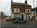
Shop formerly The New Queen Public House
Image: © Alex McGregor
Taken: 4 Jan 2012
0.17 miles
4
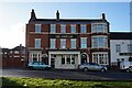
The American public house, Waterloo Road, Stoke on Trent
Image: © Ian S
Taken: 5 Jan 2022
0.21 miles
5
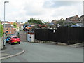
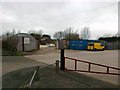
Scrapyard in Burslem
Viewed from the junction of Clyde Road and Commercial Street, a short distance south of the town centre. The clock tower of the Old Hall in Burslem can be seen in the distance.
Image: © David Weston
Taken: 18 Jul 2019
0.23 miles