IMAGES TAKEN NEAR TO
Podmore Street, STOKE-ON-TRENT, ST6 2EZ
Introduction
This page details the photographs taken nearby to Podmore Street, ST6 2EZ by members of the Geograph project.
The Geograph project started in 2005 with the aim of publishing, organising and preserving representative images for every square kilometre of Great Britain, Ireland and the Isle of Man.

There are currently over 7.5m images from over14,400 individuals and you can help contribute to the project by visiting https://www.geograph.org.uk
Image Map
Images are licensed for reuse under creativecommons.org/licenses/by-sa/2.0
Notes
- Clicking on the map will re-center to the selected point.
- The higher the marker number, the further away the image location is from the centre of the postcode.
Image Listing (15 Images Found)
Images are licensed for reuse under creativecommons.org/licenses/by-sa/2.0
Image
Details
Distance
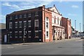
1
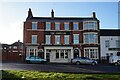
The American public house, Waterloo Road, Stoke on Trent
Image: © Ian S
Taken: 5 Jan 2022
0.07 miles
2
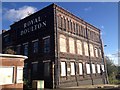
Derelict Royal Doulton works on Nile Street, Burslem
Image: © Jonathan Hutchins
Taken: 9 Nov 2013
0.10 miles
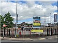
3
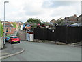
Scrapyard in Burslem
Viewed from the junction of Clyde Road and Commercial Street, a short distance south of the town centre. The clock tower of the Old Hall in Burslem can be seen in the distance.
Image: © David Weston
Taken: 18 Jul 2019
0.11 miles
4
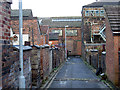
'Back to back' housing in Burslem
The backs of terraced housing in Burslem, one of the six towns of Stoke-on-Trent
Image: © Val Vannet
Taken: 13 Oct 2004
0.16 miles
5
Royal Doulton Factory (Now Gone), Burslem
Demolished Oct 2008
Image: © Brian Deegan
Taken: 2 Sep 2007
0.19 miles
7
Kiln Gate
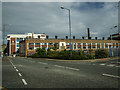
A housing development on the former Royal Doulton pottery site.
Image: © Andrew Woodvine
Taken: 28 May 2022
0.20 miles
8
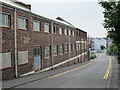
Hobson Street, Burslem
On the left is Dudson Armorlite Ltd.
Image: © David Weston
Taken: 25 Aug 2013
0.20 miles
9
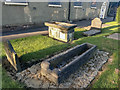
Witch Molly Leigh Grave, Burslem
Molly Leigh died in 1746 and was buried in Burslem churchyard, but there were claims that her ghost haunted the town. Spencer—along with clerics from Stoke, Wolstanton, and Newcastle-under-Lyme—exhumed her body, opened the coffin, and threw in a still-living blackbird that had been her companion. They then reburied Molly in a north to south direction, at a right angle to all the other graves in the churchyard.
https://en.wikipedia.org/wiki/Molly_Leigh
Image: © Brian Deegan
Taken: 17 Sep 2019
0.22 miles
10
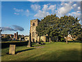
St. John's the Baptist Church, Burslem
The stone tower of St John's was built in 1536. The body of the church is of brick, built in 1717, replacing an earlier timber-framed building destroyed in a fire. The sides have tall windows with round arches
https://en.wikipedia.org/wiki/St_John_the_Baptist%27s_Church,_Burslem
Image: © Brian Deegan
Taken: 17 Sep 2019
0.23 miles