IMAGES TAKEN NEAR TO
Liverpool Road, NEWCASTLE, ST5 9ER
Introduction
This page details the photographs taken nearby to Liverpool Road, ST5 9ER by members of the Geograph project.
The Geograph project started in 2005 with the aim of publishing, organising and preserving representative images for every square kilometre of Great Britain, Ireland and the Isle of Man.

There are currently over 7.5m images from over14,400 individuals and you can help contribute to the project by visiting https://www.geograph.org.uk
Image Map
Images are licensed for reuse under creativecommons.org/licenses/by-sa/2.0
Notes
- Clicking on the map will re-center to the selected point.
- The higher the marker number, the further away the image location is from the centre of the postcode.
Image Listing (110 Images Found)
Images are licensed for reuse under creativecommons.org/licenses/by-sa/2.0
Image
Details
Distance
1
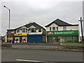
Newcastle-under-Lyme: convenience store and pizza outlet
This area is known as Cross Heath. The road in the foreground is the A34.
Image: © Jonathan Hutchins
Taken: 20 Nov 2016
0.01 miles
2
Newcastle-under-Lyme: Kimberley Road
Image: © Jonathan Hutchins
Taken: 20 Nov 2016
0.02 miles
3
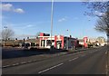
Newcastle-under-Lyme: drive-thru KFC on Liverpool Road
Image: © Jonathan Hutchins
Taken: 4 Dec 2016
0.03 miles
4
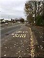
Newcastle-under-Lyme: bus stop and lay-by on Liverpool Road
Image: © Jonathan Hutchins
Taken: 20 Nov 2016
0.03 miles
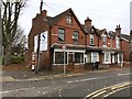
5
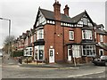
Newcastle-under-Lyme: 126 Liverpool Road
The front ground floor of this building on the corner of the A34 and Albany Road is a hairdressers called Kwik Kut.
Image: © Jonathan Hutchins
Taken: 20 Nov 2016
0.04 miles
6
Newcastle-under-Lyme: footpath and cycle path emerge onto A34
Image: © Jonathan Hutchins
Taken: 20 Nov 2016
0.05 miles
7
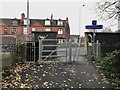
Newcastle-under-Lyme: footpath and cycle path emerge onto A34
Image: © Jonathan Hutchins
Taken: 20 Nov 2016
0.05 miles
8
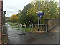
Newcastle-under-Lyme: footpath off A34
The 'Newcastle Greenway' follows a metalled path down to the main footpath, the trackbed of the former railway line to Market Drayton.
Image: © Jonathan Hutchins
Taken: 24 Oct 2015
0.05 miles
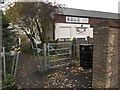
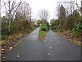
9
Newcastle-under-Lyme: path junction on cycleway
The path on the right slopes upwards to meet the A34 at ground level. The main path is a National Cycle Route, and is also the route of the long-gone Newcastle-Market Drayton railway line.
Image: © Jonathan Hutchins
Taken: 20 Nov 2016
0.06 miles
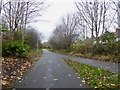
10
Newcastle-under-Lyme: path junction on cycleway
The path on the left slopes upwards to meet the A34 at ground level. The main path is a National Cycle Route, and is also the route of the long-gone Newcastle-Market Drayton railway line.
Image: © Jonathan Hutchins
Taken: 20 Nov 2016
0.06 miles