IMAGES TAKEN NEAR TO
Fearns Avenue, NEWCASTLE, ST5 8LX
Introduction
This page details the photographs taken nearby to Fearns Avenue, ST5 8LX by members of the Geograph project.
The Geograph project started in 2005 with the aim of publishing, organising and preserving representative images for every square kilometre of Great Britain, Ireland and the Isle of Man.

There are currently over 7.5m images from over14,400 individuals and you can help contribute to the project by visiting https://www.geograph.org.uk
Image Map
Images are licensed for reuse under creativecommons.org/licenses/by-sa/2.0
Notes
- Clicking on the map will re-center to the selected point.
- The higher the marker number, the further away the image location is from the centre of the postcode.
Image Listing (5 Images Found)
Images are licensed for reuse under creativecommons.org/licenses/by-sa/2.0
Image
Details
Distance
1
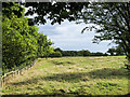
Rough grazing land between woodland and housing estate
The woodland is at the eastern side of the field and has a footpath at its edge. The housing estate is out of view in the image, across the field to the right.
Image: © Trevor Littlewood
Taken: 21 Sep 2022
0.04 miles
5
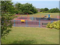
Playground off Cheswardine Road, Bradwell
On the edge of the Bradwell estate between Newcastle and Kidsgrove, by a footpath to Bradwell Wood.
Image: © Derek Harper
Taken: 30 Jun 2006
0.24 miles