IMAGES TAKEN NEAR TO
Scot Hay Road, NEWCASTLE, ST5 6RJ
Introduction
This page details the photographs taken nearby to Scot Hay Road, ST5 6RJ by members of the Geograph project.
The Geograph project started in 2005 with the aim of publishing, organising and preserving representative images for every square kilometre of Great Britain, Ireland and the Isle of Man.

There are currently over 7.5m images from over14,400 individuals and you can help contribute to the project by visiting https://www.geograph.org.uk
Image Map (Loading...)


Getting Data...Please wait
Leaflet Map data © OpenStreetMap
Images are licensed for reuse under creativecommons.org/licenses/by-sa/2.0
Notes
- Clicking on the map will re-center to the selected point.
- The higher the marker number, the further away the image location is from the centre of the postcode.
Image Listing (44 Images Found)
Images are licensed for reuse under creativecommons.org/licenses/by-sa/2.0
Image
Details
Distance
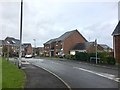
1
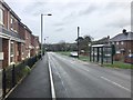
Silverdale: Scot Hay Road
On the left is the new Heritage Park estate, built on the site of the former Silverdale Colliery.
Image: © Jonathan Hutchins
Taken: 6 Nov 2016
0.01 miles
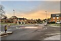
2
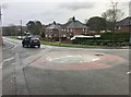
Silverdale: mini-roundabout outside Heritage Park
Image: © Jonathan Hutchins
Taken: 6 Nov 2016
0.03 miles
4
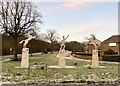
Philip Astley sculpture, Silverdale
Philip Astley (1742-1814), Newcastle-under-Lyme's most famous son, has been described as 'the father of the modern circus'. Subway art in the town centre also celebrates him, e.g. https://www.geograph.org.uk/photo/5311710
Image: © Jonathan Hutchins
Taken: 10 Dec 2022
0.04 miles
5
Silverdale: Sutton Avenue
On the new development called Heritage Park, built on the site of the former Silverdale Colliery.
Image: © Jonathan Hutchins
Taken: 6 Nov 2016
0.04 miles
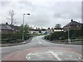
6
Mini-roundabout in Silverdale
To the left on the far side of the roundabout is the Philip Astley sculpture seen in https://www.geograph.org.uk/photo/7359312
Image: © Jonathan Hutchins
Taken: 10 Dec 2022
0.05 miles
7

Edge of housing estate, Silverdale
On the site of the former Silverdale Colliery.
Image: © Jonathan Hutchins
Taken: 10 Dec 2022
0.05 miles
8

Silverdale: car park for Kents Lane Community Building
Image: © Jonathan Hutchins
Taken: 6 Nov 2016
0.05 miles
9
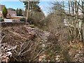
Route of old railway line, Silverdale
This is part of the former Stoke to Market Drayton line, see https://en.wikipedia.org/wiki/Stoke_to_Market_Drayton_Line
Image: © Jonathan Hutchins
Taken: 10 Dec 2022
0.07 miles
10
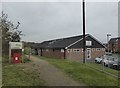
Silverdale: Kents Lane Community Building
'The home of Silverdale Athletic FC founded 1980'.
On the left is a path and signboard for Silverdale Country Park.
Image: © Jonathan Hutchins
Taken: 6 Nov 2016
0.07 miles