IMAGES TAKEN NEAR TO
Pepper Street, NEWCASTLE, ST5 6QJ
Introduction
This page details the photographs taken nearby to Pepper Street, ST5 6QJ by members of the Geograph project.
The Geograph project started in 2005 with the aim of publishing, organising and preserving representative images for every square kilometre of Great Britain, Ireland and the Isle of Man.

There are currently over 7.5m images from over14,400 individuals and you can help contribute to the project by visiting https://www.geograph.org.uk
Image Map (Loading...)


Getting Data...Please wait
Leaflet Map data © OpenStreetMap
Images are licensed for reuse under creativecommons.org/licenses/by-sa/2.0
Notes
- Clicking on the map will re-center to the selected point.
- The higher the marker number, the further away the image location is from the centre of the postcode.
Image Listing (29 Images Found)
Images are licensed for reuse under creativecommons.org/licenses/by-sa/2.0
Image
Details
Distance
1
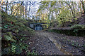
Silverdale Railway Tunnel East Side (Disused)
Built around 1863 and is 68 Yards long and is on the old Stoke to Market Drayton line. Closed in 1998. The Tracks are still in place in the tunnel, and on the west side of the tunnel heading out to Madeley and Keele https://www.geograph.org.uk/photo/6096882
https://en.wikipedia.org/wiki/Stoke_to_Market_Drayton_Line
Image: © Brian Deegan
Taken: 10 Nov 2019
0.03 miles
2
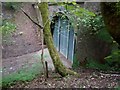
Entrance to Silverdale Railway Tunnel
New fence erected in 2018 due to a body found, but at the date of upload, has been broken open again. A ~550m long old railway tunnel, which makes a nice walk to the ruins of Madeley Manor
Image: © nine1seven3oh
Taken: 27 May 2018
0.07 miles
4
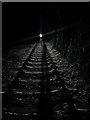
Silverdale Railway Tunnel Middle (Disused)
Built around 1863 and is 68 Yards long and is on the old Stoke to Market Drayton line. Closed in 1998. The Tracks are still in place in the tunnel.
https://en.wikipedia.org/wiki/Stoke_to_Market_Drayton_Line
Image: © Brian Deegan
Taken: 9 Dec 2019
0.14 miles
5
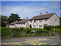
Matlock Place, Park Site
The small green space, off Buxton Avenue, is a pleasant alternative to a short cul de sac.
Image: © Richard Vince
Taken: 29 Jun 2013
0.14 miles
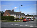
6
Thirsk Place, Park Site
A short cul de sac off Buxton Avenue, providing access to a set of garages as well as houses.
Image: © Richard Vince
Taken: 29 Jun 2013
0.14 miles
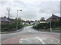
7
Malvern Avenue, Park Site
A very short road, seen from Bath Road; the far end of Malvern Avenue can be seen on the right.
Image: © Richard Vince
Taken: 29 Jun 2013
0.15 miles
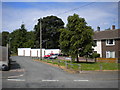
9
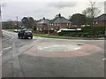
Silverdale: mini-roundabout outside Heritage Park
Image: © Jonathan Hutchins
Taken: 6 Nov 2016
0.17 miles
10
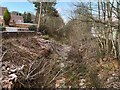
Route of old railway line, Silverdale
This is part of the former Stoke to Market Drayton line, see https://en.wikipedia.org/wiki/Stoke_to_Market_Drayton_Line
Image: © Jonathan Hutchins
Taken: 10 Dec 2022
0.18 miles